
A Study Guide to El Niño and Hurricane Season
Learn how El Niño suppresses Atlantic hurricane activity through increased vertical wind shear, and review the key statistics on landfall probabilities and seasonal forecasts for exam preparation.
Updated:
The exam version of the question is simple: how does El Niño affect Atlantic hurricane season? The answer is not “warm water makes more storms.” El Niño usually suppresses Atlantic hurricane activity because it changes the wind structure over the Atlantic, especially the amount of vertical wind shear.
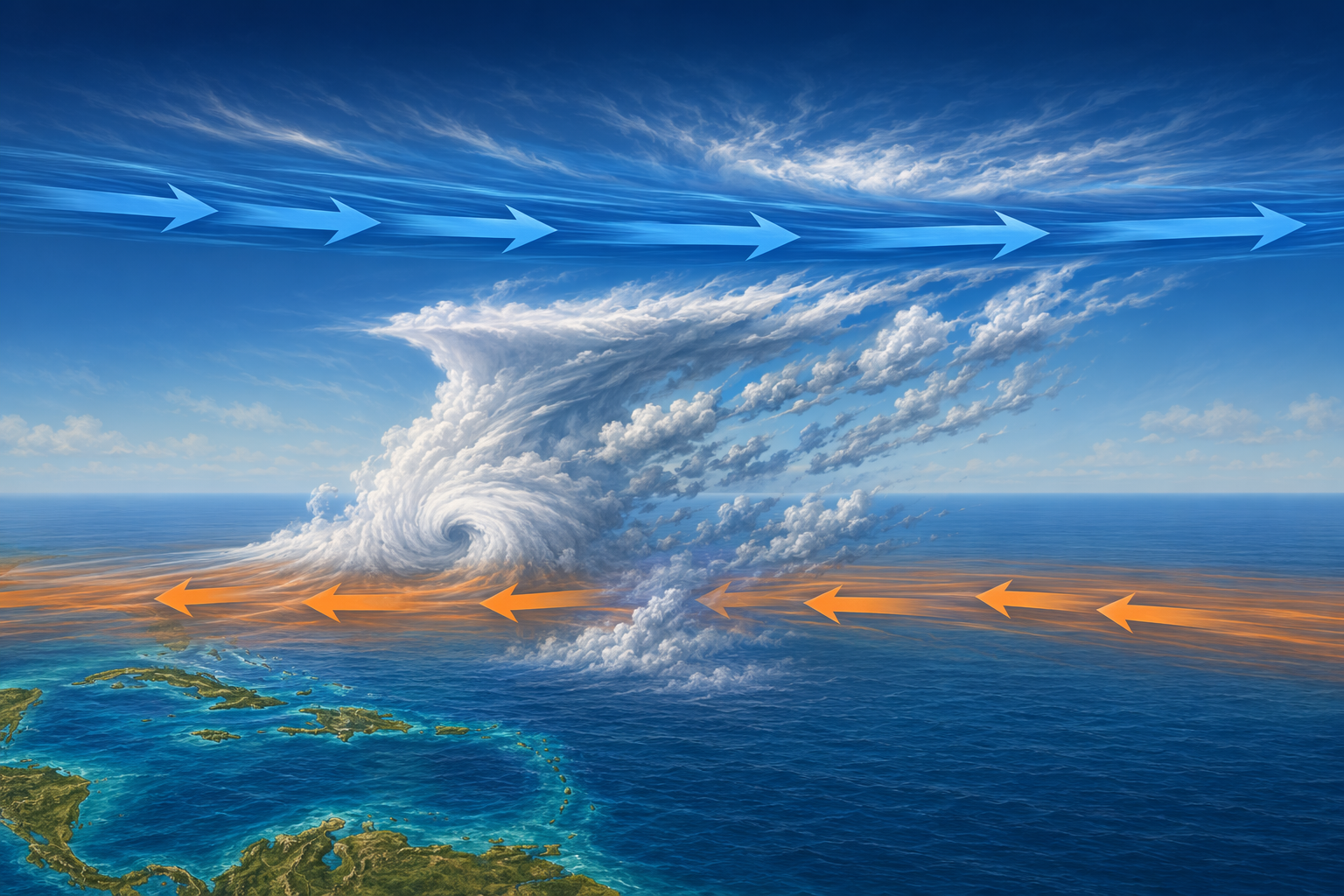
During El Niño, upper-level westerly winds over the tropical Atlantic strengthen, while lower-level easterly trade winds also strengthen. That creates a larger speed-and-direction mismatch between winds roughly 5,000 to 35,000 feet above the surface. Developing tropical cyclones need vertically stacked circulation; strong shear tilts and disrupts that structure before the storm can organize efficiently.[1]
That is the load-bearing idea for an El Niño hurricane season study guide: El Niño changes Atlantic wind shear. Sea surface temperature still matters, moisture still matters, and a storm still needs a disturbance to start from. But if the upper and lower atmosphere are pulling the storm in different directions, the storm has a harder time building the upright heat engine that hurricanes require.
The mechanism: ENSO changes the Atlantic by moving the winds
ENSO stands for El Niño-Southern Oscillation, the recurring climate pattern tied to sea surface temperature and atmospheric pressure changes across the tropical Pacific. El Niño is the warm phase, La Niña is the cool phase, and neutral conditions sit between them.[2] That Pacific definition is useful, but it is not where the hurricane answer stops.
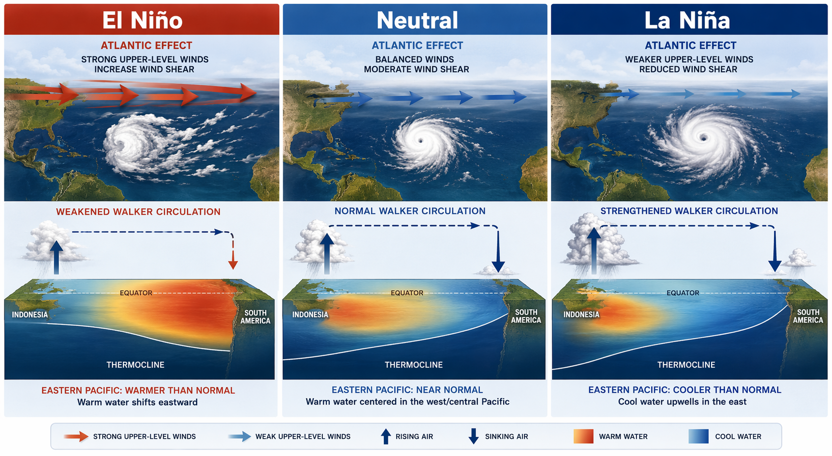
The bridge from the Pacific to the Atlantic is the Walker Circulation: an east-west tropical circulation pattern in which warm ocean water, rising air, sinking air, and trade winds are linked across the equatorial Pacific. When the warm water and rising branch of that circulation shift during El Niño, the tropical wind pattern shifts with it.[3]
For Atlantic hurricanes, the important result is vertical wind shear. NOAA’s Atlantic Oceanographic and Meteorological Laboratory explains the El Niño pattern this way: stronger upper-level westerlies combine with stronger lower-level easterlies over the Atlantic, increasing the vertical shear that interferes with storm development.[1]
A compact way to remember it: El Niño starts in the Pacific, but the hurricane consequence shows up over the Atlantic as shear.
El Niño, neutral, and La Niña side by side
Students often memorize El Niño as “Pacific warming” and La Niña as “Pacific cooling,” then lose the hurricane part. The better comparison keeps the phases tied to their Atlantic wind consequences.
| ENSO phase | Pacific pattern | Atlantic wind-shear effect | Usual Atlantic hurricane effect |
|---|---|---|---|
| El Niño | Warmer-than-average central/eastern tropical Pacific | Stronger vertical wind shear over the tropical Atlantic | Suppressed hurricane formation and organization |
| Neutral | No strong El Niño or La Niña pattern | No strong ENSO-driven shear signal | Activity closer to the long-term middle, depending on other conditions |
| La Niña | Cooler-than-average central/eastern tropical Pacific | Reduced vertical wind shear over the tropical Atlantic | More favorable environment for Atlantic hurricane activity |
Notice the dimension being compared. It is not “which phase has the warmest ocean somewhere on Earth?” It is “which phase makes the Atlantic atmosphere more or less hostile to organized tropical cyclones?” That is why La Niña can be associated with more Atlantic hurricane activity even though its defining temperature signal is cooler water in the tropical Pacific.
Neutral years are not automatically quiet or average in every basin. They simply lack the strong ENSO push that El Niño or La Niña adds to the background pattern. Atlantic sea surface temperatures, steering patterns, dust, intraseasonal pulses, and random weather timing still matter.
The numbers worth remembering
The cleanest study statistics come from research summarized by NOAA/AOML using 1900-1997 data. The probability of two or more U.S. hurricane landfalls was 28% during El Niño years, 48% during neutral years, and 66% during La Niña years.[4]
| ENSO phase | Probability of 2+ U.S. hurricane landfalls | Mean annual number of U.S. hurricanes |
|---|---|---|
| El Niño | 28% | 1.04 |
| Neutral | 48% | 1.61 |
| La Niña | 66% | 2.23 |
Those values are useful because they connect the physical mechanism to an outcome people care about: U.S. hurricane landfalls. The same NOAA/AOML summary gives mean annual U.S. hurricane counts of 1.04 in El Niño years, 1.61 in neutral years, and 2.23 in La Niña years.[4]
Do not overread those numbers. They are historical probabilities from 1900-1997, not a guarantee for any single season. A low-probability El Niño season can still produce a damaging landfall, and an active La Niña season can still steer many storms away from land. The exam point is the pattern: El Niño lowers the odds and averages; La Niña raises them.
How the 2026 outlook uses the same pattern
Current seasonal forecasts apply the same logic, but they are not proof of the mechanism by themselves. For 2026, NOAA’s outlook reported a 55% probability of a below-average Atlantic hurricane season, while Colorado State University forecast 13 named storms, 6 hurricanes, and 2 major hurricanes.[5]
Those figures are a forecast snapshot, not a fixed answer key. Seasonal outlooks can change as ocean temperatures, atmospheric patterns, and early-season observations update. They are best used here as an example of how forecasters translate ENSO conditions and other climate signals into expected storm activity.
The important study move is to separate signal from certainty. Forecasters may use ENSO as one input because the El Niño-shear relationship is physically meaningful. That does not mean ENSO alone determines the final hurricane count or landfall pattern.
What can weaken the El Niño suppression?
El Niño is a strong clue, not a remote control. Very warm Atlantic sea surface temperatures can partially offset the suppressing effect of stronger shear by giving storms more ocean heat to work with. That is one reason a season can look more active than a simple “El Niño equals quiet” rule would suggest.
Other factors can also shift the season: the Madden-Julian Oscillation can temporarily favor or suppress tropical development, the Bermuda High can affect steering and landfall risk, and the Saharan Air Layer can introduce dry, dusty air that inhibits storms. These do not erase ENSO; they sit on top of it.
That distinction matters because a correct answer should not claim that El Niño prevents hurricanes. It usually makes the Atlantic environment less favorable by increasing vertical wind shear. “Less favorable” is not the same as “impossible.”
A fast exam answer you can build from
If you have to answer in a few sentences, use the causal chain rather than a loose climate phrase:
- ENSO changes tropical Pacific ocean-atmosphere circulation.
- During El Niño, the Walker Circulation shifts and alters upper- and lower-level winds across the tropics.
- Over the Atlantic, stronger upper-level westerlies and lower-level easterlies increase vertical wind shear.
- That shear tilts and disrupts developing tropical cyclones, so Atlantic hurricane activity and U.S. landfall probabilities usually decrease.
- During La Niña, shear is generally reduced, making the Atlantic more favorable for hurricane development.
For a longer study guide, put this topic into a larger review system: start with a course outline using the syllabus-to-study-guide method, place it inside a broader 16-week AP study plan, or schedule a short review block with a weekly study schedule. But the hurricane-season concept itself is small enough to hold in one sentence: El Niño usually suppresses Atlantic hurricanes because it increases vertical wind shear; La Niña usually does the opposite.
References
- How does El Niño impact Atlantic hurricane season?, NOAA Atlantic Oceanographic and Meteorological Laboratory
- What is the El Niño-Southern Oscillation (ENSO) in a nutshell?, NOAA Climate.gov
- El Niño, NASA Science
- El Niño and U.S. Landfalling Hurricanes, NOAA Atlantic Oceanographic and Meteorological Laboratory
- El Niño is coming, University of Miami Rosenstiel School, April 2026
Comments
Join the discussion with an anonymous comment.