
How to Read Tornado Alerts: Watch, Warning, Emergency
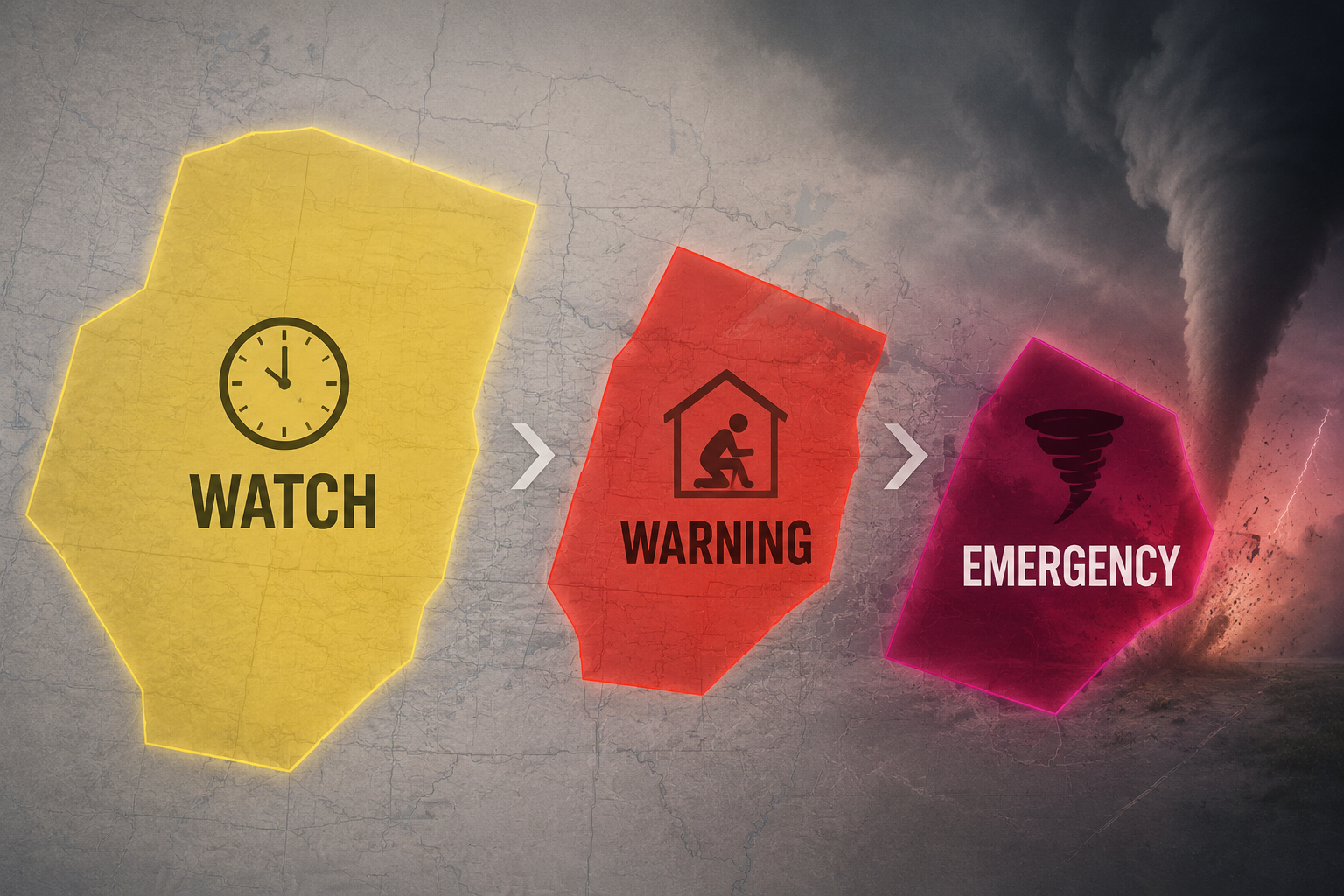
Tornado warnings come in three tiers — Watch, Warning, and Emergency — each with a distinct map shape, color, and tag. This guide explains how to read each alert level, what the polygon colors mean on weather apps, and the action each level requires.
Updated:
When a tornado alert hits your phone, the first job is not to decide whether the sky looks scary. It is to identify which alert tier you received, check whether you are inside the warned area, and move at the speed that tier requires. A Watch gives you preparation time. A Warning means shelter now. A Tornado Emergency means a life-threatening tornado situation is already in progress.
That sounds simple until the alert arrives during a lecture, in a dorm hallway, at work, or while driving. The map may show a yellow box, a red polygon, a county name, a storm marker, or a stronger damage-threat tag. Here is the fast decoder before the details.
| Alert level | Common map color | Typical duration | Area shown | Tag system | Required action |
|---|---|---|---|---|---|
| Tornado Watch | Yellow | Often 5-8 hours | Broad watch area, often covering many counties | No tornado damage-threat tag | Prepare: know your shelter, charge your phone, keep shoes nearby, monitor updates |
| Tornado Warning | Red | Often around 30 minutes | Smaller storm-relative warning polygon | Base, Considerable/PDS, or Catastrophic when escalated | Shelter now: go to a basement or interior room away from windows |
| Tornado Emergency | Deep red, purple-red, or otherwise emphasized depending on app | Issued within the warning process as the situation escalates | Most urgent part of the warned storm area | Catastrophic / Tornado Emergency | Treat as a violent, life-threatening situation in progress; get under sturdy protection immediately |
Watch Means Prepare, Not Hide
A Tornado Watch means conditions are favorable for tornadoes in and near the watch area. It does not mean a tornado has been spotted over your building, and it does not usually mean you need to sit in a shelter for hours. The National Weather Service’s basic distinction is plain: a Watch means be prepared; a Warning means take action.[1]
On many maps, the Watch appears as a broad yellow box or shaded area. It can cover a wide region because the question is still environmental: storms capable of producing tornadoes may develop. The practical move is to remove friction before the warning arrives. Find the nearest sturdy shelter. Charge the phone. Put shoes where you can reach them. If you are responsible for other people, make sure they know where to go before everyone is staring at separate apps.
For a student, that may mean learning whether the dorm shelter is the lowest interior hallway, a designated basement room, or a posted severe-weather area. In an apartment, it may mean choosing the bathroom or closet before the sirens start. In a library, it may mean noticing the interior stairwell instead of assuming the front entrance is safest.
Warning Means Shelter Now
A Tornado Warning is different. It means a tornado has been sighted or indicated by weather radar, and the instruction changes from preparation to immediate protective action.[1] If this is the alert that buzzed your phone, do not wait for a second app, a better screenshot, or proof from the window.
This is where a lot of bad decisions happen. Someone sees a county name and thinks the warning must include the whole county. Someone else sees a red shape nearby and assumes nearby is the same as inside. Another person has lived through false alarms and decides this one is probably wrong too. None of those reactions is a shelter plan.
For a Warning, go to the lowest level you can reach quickly. A basement is best when available. If not, choose a small interior room or hallway away from windows. The NWS also advises protecting your head, including with a helmet or sturdy covering when possible.[1]
In a car, the decision is harder and more location-specific, but the same rule holds: do not treat the alert as a suggestion to keep driving into the warned area. If you can get to a sturdy building immediately, do that. If you cannot, follow official instructions in the alert and from local emergency management.
Emergency Means the Warning Has Become More Severe
A Tornado Emergency is not a fourth casual label for bad weather. It is a rare escalation used for an extremely dangerous, life-threatening tornado situation. The National Weather Service’s impact-based warning language treats the highest category as catastrophic, with language such as “tornado emergency” used for the most severe threat level.[2]
If your alert says Tornado Emergency, the time for checking whether other people are taking it seriously has passed. Move to the strongest shelter you can reach, get away from glass, get low, and protect your head and neck. If you supervise a group, this is the moment for short instructions, not explanations.
The Polygon Is the Part People Misread
Modern tornado warnings are not meant to scare every person in a whole county equally. The National Weather Service shifted from county-based warnings to storm-based polygon warnings in 2007, so the warned area could more closely follow the part of the storm expected to pose danger.[3]
That polygon matters more than the county name in the alert header. If your location dot is inside the red warning polygon, act. If you are just outside it, stay ready and keep monitoring, because storms move and warnings can be updated. If your county is named but your exact location is outside the polygon, your app may still be showing county-level context; use the polygon to refine your decision, not to talk yourself out of awareness.
Some weather maps also show a storm-cell marker or a pulsing dot for the current storm location. That can help you see why the polygon points in a particular direction: it is drawn around where the storm is and where it is expected to go, not around a neat political boundary.[4]
The safe habit is a three-part check: read the alert word, find your location dot, then compare it with the polygon. Do not zoom so far out that the red shape looks like a general regional blob. Do not zoom so far in that you miss the storm track. If the alert says Warning and your dot is inside the polygon, the interpretation is finished: shelter.
Inside, Near, and Outside Are Different Decisions
| Where you are | What it means | What to do |
|---|---|---|
| Inside the red warning polygon | You are in the warned area | Shelter immediately |
| Near the edge of the polygon | You may be close to the warned storm path or close to later updates | Be ready to shelter immediately; keep the alert open |
| In the same county but outside the polygon | Your county may be mentioned, but your exact spot may not be in the warned area | Monitor closely; do not ignore later updates |
| Inside a yellow watch area only | Conditions are favorable, but no warning is active for your exact location | Prepare and keep reliable alerts on |
Damage-Threat Tags Change the Urgency Within a Warning
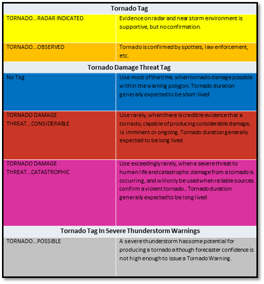
Not all Tornado Warnings carry the same impact language. Impact-Based Warning tags are meant to tell the public and emergency managers how severe the expected damage threat is, not just that a tornado warning exists.[2]
| Damage-threat language | What it signals | How to treat it |
|---|---|---|
| Base | A tornado warning without the higher damage-threat wording | Shelter now; this is still a tornado warning |
| Considerable / PDS | A particularly dangerous situation with a more serious life-threatening threat | Move faster, use the strongest shelter available, and do not delay for confirmation |
| Catastrophic / Tornado Emergency | The highest-impact wording for an exceptionally dangerous situation | Get under sturdy protection immediately and protect your head from debris |
The tag is not a reason to stay put during a “base” warning. A base Tornado Warning already means shelter now. The higher tags tell you that the consequences may be worse and the margin for hesitation is thinner.
This is also where app screenshots can mislead. One app may emphasize a dramatic color. Another may hide the tag lower in the alert text. A third may show the polygon clearly but make the wording hard to find. Read the words “Tornado Warning,” “Particularly Dangerous Situation,” “Considerable,” “Catastrophic,” and “Tornado Emergency” as instructions, not decoration.
What the Phone Alert Does and Does Not Tell You
Wireless Emergency Alerts are designed to interrupt you for immediate hazards. Tornado warnings trigger these alerts, and destructive severe thunderstorm warnings with 80 mph or greater winds can also trigger phone alerts.[5]
That second point matters because not every loud phone alert during a storm is a Tornado Warning. Read the alert type. If it says Tornado Warning, shelter now. If it says destructive Severe Thunderstorm Warning, take it seriously too, especially because very high winds can break windows, throw debris, and create dangerous conditions, but do not confuse it with the tornado alert hierarchy.
If your phone buzzes and the map will not load, do not wait in a window trying to refresh it. Use the alert text you have. A tornado warning on the phone is enough to move to shelter while the map catches up.
Campus Alerts Add One More Layer
On a campus, the official weather alert is only the first handoff. Then the message has to travel through residence life, classroom instructors, building staff, sirens, social media, group chats, and students who may have silenced notifications. A study of tornado warning dissemination at Mississippi State University examined how students received and responded to warnings during a 2010 event, making it useful for understanding campus behavior, but dated for today’s phone environment.[6]
The age of that study matters. Student phone use, alert settings, and campus notification systems have changed since 2010.
If you are in a dorm, classroom, library, dining hall, or lab, the best interpretation is the one that turns into a route. Which stairwell leads down? Which hallway has no windows? Which room can hold people away from exterior glass? If the alert is a Watch, answer those questions. If it is a Warning, use the answers.
This is the same kind of practical reading skill used for other National Weather Service hazards. A Red Flag Warning study guide has a different hazard, but the same first move: identify the official warning, then translate it into behavior.
A Simple Reading Order for Any Tornado Alert
- Read the alert tier first: Watch, Warning, or Emergency.
- Check your location against the polygon, not just the county name.
- Look for damage-threat wording such as Considerable, PDS, Catastrophic, or Tornado Emergency.
- Match the action to the tier: prepare for Watch, shelter for Warning, use the strongest protection immediately for Emergency.
- Keep monitoring only after you have taken the action the alert requires.
The safest reader is not the person who can explain radar signatures. It is the person who can look at a phone alert, identify the tier, see whether they are inside the polygon, recognize the tag, and move at the correct speed.
References
- Tornado Safety — National Weather Service
- Impact Based Warnings — National Weather Service Chicago
- Severe weather terminology — Wikipedia
- Reading the Warning Map — TornadoPath
- Tornado Warning Polygon: What It Means and How to Respond — Survive-A-Storm
- How do college students respond to tornado warnings? — Journalist’s Resource
Comments
Join the discussion with an anonymous comment.