
What Is Atlantic Niña and Why Should Students Care?
Atlantic Niña is a smaller, shorter-lived climate pattern that cools the equatorial Atlantic and shifts rainfall across West Africa and South America. This guide explains how it forms, how it differs from the Pacific La Niña, and what it means for hurricane seasons — with plain language and real data.
Updated:
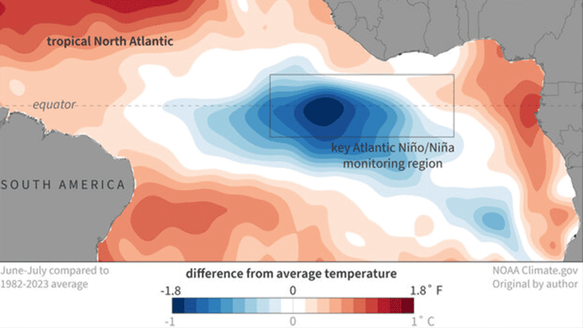
Atlantic Niña is a period when sea surface temperatures in a narrow strip of the equatorial Atlantic Ocean become cooler than usual. More precisely, scientists look for the eastern equatorial Atlantic to be at least 0.5°C cooler than average for a three-month season before treating it as an Atlantic Niña event. That small number matters because the equator is where the ocean and atmosphere talk to each other most efficiently: a little cooling in the right place can change winds, rising air, clouds, rain, and the early ingredients for some Atlantic hurricanes. [1]
For students, the important phrase is not “rare climate event.” It is “ocean-atmosphere pattern.” Atlantic Niña is the cool phase of a pattern called the Atlantic zonal mode. In classroom language, that means the eastern and western sides of the tropical Atlantic do not always warm and cool evenly. When the eastern side near Africa cools enough, for long enough, the atmosphere above it can respond.
How Scientists Decide Whether Atlantic Niña Is Happening
A single cool week does not count. Neither does one dramatic map. NOAA describes Atlantic Niña using a seasonal average, usually over three months, because ocean-atmosphere patterns need persistence. The common threshold is a sea surface temperature anomaly of -0.5°C or cooler in the eastern equatorial Atlantic. An anomaly is just the difference from the long-term average for that place and time of year. [1]
| Question | Student-friendly answer |
|---|---|
| Where is it? | In the tropical Atlantic near the equator, especially toward the eastern side near West Africa. |
| What changes? | Sea surface temperatures become cooler than average. |
| How cool is cool enough? | About -0.5°C or more below average. |
| How long must it last? | Scientists look at a three-month seasonal average, not a single day or week. |
| What is the formal climate pattern? | The cool phase of the Atlantic zonal mode. |
That detection rule is useful because it keeps students from treating every patch of blue on a temperature map as a named climate event. Climate scientists are watching a pattern, not naming a mood.
Atlantic Niña Is Related to Pacific La Niña, But It Is Not a Copy
If you already know Pacific La Niña, use it as a ladder, then step off the ladder. Pacific La Niña is the cool phase of the El Niño-Southern Oscillation, or ENSO, in the tropical Pacific. It has broad global effects because the Pacific is enormous and because ENSO strongly rearranges tropical rainfall and winds. Atlantic Niña is smaller, shorter-lived, and less studied. The Conversation describes it as La Niña’s “smaller cousin,” which is a helpful doorway as long as the analogy does not become the whole explanation. [2]
The two patterns can also push against each other. One scientist quoted by The Conversation compared the situation to “two pendulums swinging in opposite directions,” because the Pacific and Atlantic systems may send different signals into the atmosphere at the same time. [2] That matters for hurricane season: a Pacific La Niña can reduce wind shear over the Atlantic, which often favors hurricane development, while an Atlantic Niña may cool part of the tropical Atlantic in a way that can dampen some hurricane ingredients. NOAA cautions that the Atlantic signal is weaker and can be overridden by ENSO. [1]
The Mechanism: Stronger Trade Winds, More Upwelling, Cooler Surface Water
Start with the normal summer setup. Trade winds blow across the tropical Atlantic. When those winds strengthen, they push warm surface water westward, away from the eastern equatorial Atlantic. Water has to replace it, so colder water rises from below. That upward movement is called upwelling.
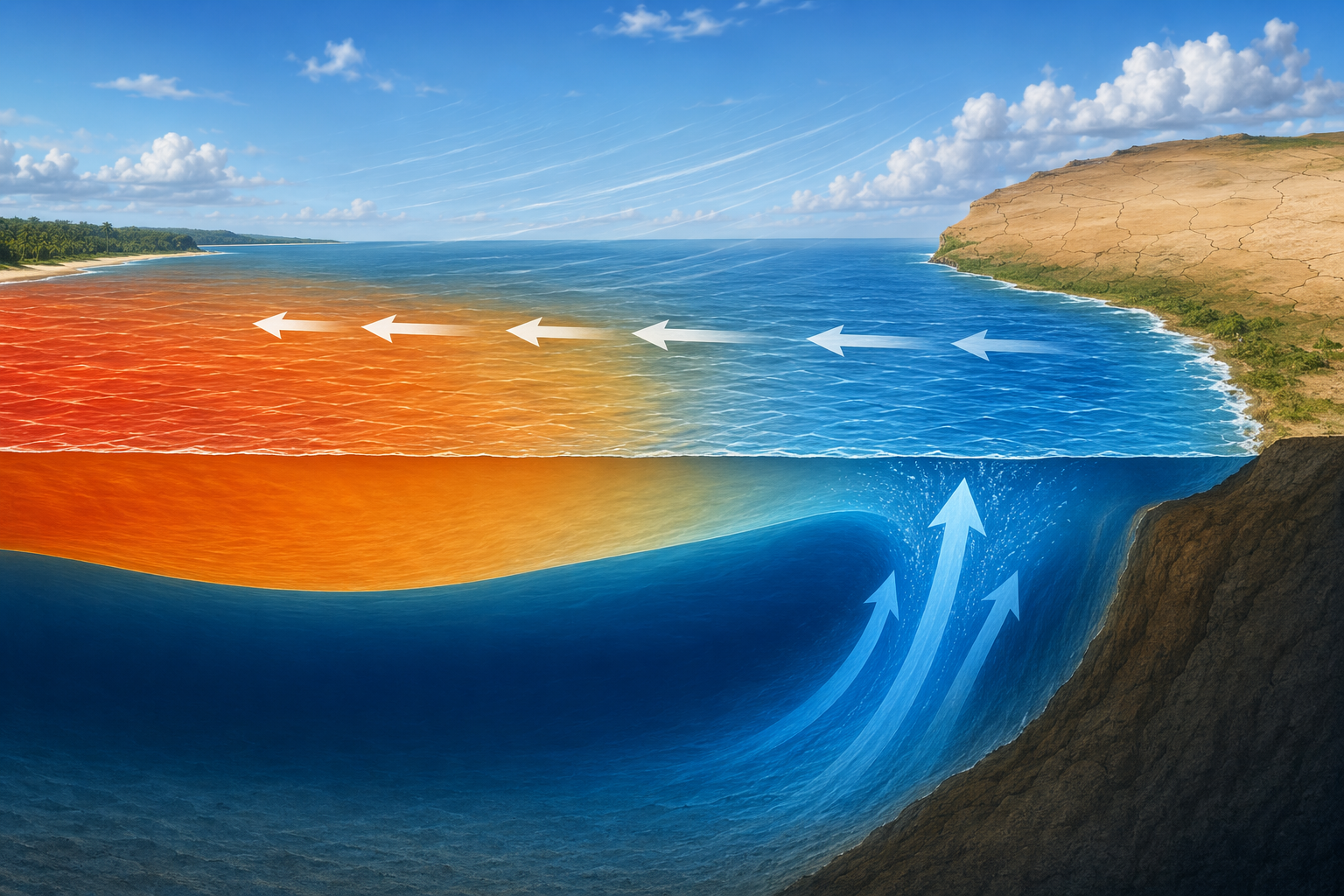
This is the cleanest mental model for Atlantic Niña: stronger summer trade winds push warm water away; upwelling brings cooler water up; the ocean surface cools near the equator; the atmosphere above that cooler patch changes how easily warm, moist air rises.
Why does cooler surface water matter for rainfall? Warm ocean water is a fuel source for evaporation and rising air. Cooler water usually means less evaporation from that patch and less local rising motion. In the tropics, where rainfall often depends on moist air rising into thunderstorms, shifting the warmest and coolest ocean areas can shift where clouds and rain are favored.
That is why Atlantic Niña is not just a vocabulary word. NOAA notes that Atlantic Niña can influence rainfall around the tropical Atlantic, including parts of West Africa and South America, though the exact impacts are still an active research area. [1] A student answer should keep both halves: there is a real link to rainfall patterns, and the science is not as settled or as globally powerful as the Pacific ENSO story.
Why Such a Small Cooling Can Show Up in Hurricane Statistics
Atlantic Niña does not “control” hurricane season. That sentence is worth saying plainly because it prevents a lot of bad forecasting. Hurricanes need many ingredients: warm water, moist air, low wind shear, pre-existing disturbances, and room to organize. Atlantic Niña touches some of those ingredients, especially in the eastern tropical Atlantic where many Cape Verde-type hurricanes begin.
The strongest reason students should care comes from a 2023 Nature Communications study by Kim and coauthors. The study compared hurricane activity during Atlantic Niño years, the warm phase, and Atlantic Niña years, the cool phase. It found about 2.9 tropical cyclones per year during Atlantic Niña years, compared with about 5.1 per year during Atlantic Niño years. For major hurricanes, the comparison was about 0.92 per year during Atlantic Niña and about 2.16 per year during Atlantic Niño. [3]
Those numbers do not turn Atlantic Niña into a forecast button. They show a measurable contrast in past seasons. The study’s mechanism is also specific: Atlantic Niña cools the eastern Atlantic and is associated with weaker African easterly wave activity and a weaker West African westerly jet, both of which matter for Cape Verde hurricane formation. [3]
Cape Verde hurricanes are storms that form from tropical disturbances coming off Africa and then develop over the eastern tropical Atlantic. They can become intense if they travel over warm water with favorable winds. If the eastern Atlantic is cooler and the atmospheric wave activity is less favorable, fewer of those disturbances may organize. That is a narrower claim than “Atlantic Niña stops hurricanes,” and it is the claim the evidence can actually carry.
Rarity Makes It Interesting, Not All-Powerful
Atlantic Niña events are uncommon in the modern record. Fox Weather reported that only about half a dozen Atlantic Niña events have been recorded since the early 1980s. [4] That rarity is one reason a developing event attracts attention, but rarity by itself does not tell you the size of the impact.
A rare pattern can still be modest. A common pattern can still be powerful. For Atlantic Niña, the responsible statement is that it is a real regional climate signal with measurable links to rainfall and Cape Verde hurricane formation, but it is not the main steering wheel for the whole Atlantic basin.
What the 2026 Cooling Does, and Does Not, Let Us Say
The reason Atlantic Niña is getting fresh attention in Q3 2026 is that unusually cool water has been observed in the equatorial Atlantic. Severe Weather Europe described a rare Atlantic Niña emerging in 2026 and connected it to the broader climate setup following the recent strong El Niño period. [5] That makes the concept feel less like a textbook footnote and more like a live example.
But a live example is not the same thing as a formal declaration. As of the research window for this article, NOAA had not formally declared a 2026 Atlantic Niña. The careful wording is: if the cooling persists long enough to meet the seasonal threshold, it may qualify as an Atlantic Niña event. That one word, “if,” is doing real scientific work.
Current-condition articles sometimes move quickly from Atlantic Niña to winter weather speculation or hurricane-season certainty. Students should slow that down. The Atlantic pattern is only one input. ENSO, Atlantic-wide sea surface temperatures, wind shear, Saharan dust, humidity, and short-term weather patterns can all matter. NOAA’s caution is especially important here: the Atlantic Niña signal is weaker than ENSO and can be muted or overwhelmed by it. [1]
Atlantic Niño Is the Warm-Phase Contrast
Atlantic Niña is easier to remember if you pair it with Atlantic Niño. Atlantic Niño is the warm phase of the same Atlantic zonal mode: the eastern equatorial Atlantic becomes warmer than usual instead of cooler. NOAA’s Atlantic Oceanographic and Meteorological Laboratory has described Atlantic Niño as a pattern that can fuel intense tropical cyclones by warming the eastern tropical Atlantic, which helps explain why Kim et al. found higher Cape Verde hurricane counts during Atlantic Niño years than during Atlantic Niña years. [6][3]
The contrast is useful because it keeps the focus on mechanism. Warmer eastern Atlantic water can support more evaporation, rising air, and storm development if other conditions cooperate. Cooler eastern Atlantic water can make that region less supportive. Neither phase acts alone.
An Exam-Ready Way to Say It
If you need one durable sentence, use this:
Atlantic Niña is the cool phase of the Atlantic zonal mode, identified when the eastern equatorial Atlantic stays about 0.5°C or more below average for a three-month season; it forms when stronger trade winds increase upwelling, and it can shift tropical rainfall and reduce some Cape Verde hurricane ingredients, although its effects are weaker than Pacific ENSO.
That sentence does three things a good climate explanation should do. It names the pattern, gives the mechanism, and limits the claim. Small ocean temperature shifts can matter, but a careful explanation always says how strong the effect is, how certain the evidence is, and what larger systems might override it.
References
- Four things to know about a possible Atlantic Niña, NOAA Climate.gov
- What is an Atlantic Niña? How La Niña's smaller cousin could affect hurricane season, The Conversation
- Increase in Cape Verde hurricanes during Atlantic Niño, Nature Communications, 2023
- Is there a weather phenomenon known as the Atlantic Nina?, Fox Weather
- A Rare Atlantic Niña Emerges after a Super El Niño, producing an Atmospheric Shield for the United States, Severe Weather Europe
- Atlantic Niño fuels intense tropical cyclones, NOAA Atlantic Oceanographic and Meteorological Laboratory
Comments
Join the discussion with an anonymous comment.