
WEATHER Exam Hub
El Niño Study Guide for Weather Exam Questions
This study guide zeros in on the small, testable ENSO core that weather exams actually ask about — the Niño-3.4 definition and threshold, trade-wind and Walker-circulation mechanism, US winter impacts, and hurricane-season effects. It maps those facts to the recurring question formats and answer logic that intro meteorology, earth science, oceanography, and AP Environmental Science exams expect.
- gre
- mcat
- asvab
- sat
- act
- digital-adaptive
- official-material
- section-strategy
- test-date-timeline
If your weather exam asks about El Niño, the first answer it usually wants is smaller than the topic feels: El Niño is the warm phase of ENSO, identified by unusually warm sea-surface temperatures in the Niño-3.4 region of the equatorial Pacific, with the ocean warming coupled to a change in the atmosphere. For the classic ONI definition, the Niño-3.4 region is 5°N–5°S and 120°W–170°W, and El Niño conditions require the three-month running mean sea-surface temperature anomaly there to be at least +0.5°C for five consecutive overlapping three-month seasons, along with an atmospheric response.[1][2]
That sentence is almost the whole multiple-choice nucleus. For a free-response answer, it is not enough. You need the mechanism: trade winds weaken, warm water shifts eastward, upwelling of cold nutrient-rich water along the eastern Pacific is reduced, convection shifts east, the Walker circulation changes, and jet-stream patterns change downstream. Then you attach impacts carefully: U.S. winter effects are probabilistic, not guaranteed; Atlantic hurricane activity tends to be suppressed during El Niño while central and eastern Pacific hurricane activity tends to be enhanced; La Niña generally flips those patterns.
This guide is meant for the exam lane: intro meteorology, earth science, oceanography, climate units, and AP Environmental Science-style ENSO questions. If your course is narrower, such as aviation weather, your instructor may care more about operational weather hazards than the full ENSO index language. Otherwise, the highest-yield work is to practice the repeatable answer patterns below, not to memorize a tour of every famous El Niño year.
The exam-core version of El Niño
| What the question asks | Answer that usually earns points |
|---|---|
| What is El Niño? | The warm phase of ENSO, involving anomalously warm sea-surface temperatures in the central/eastern equatorial Pacific and coupled ocean-atmosphere changes. |
| Where is it measured? | The standard ONI region is Niño-3.4: 5°N–5°S, 120°W–170°W. |
| What is the threshold? | For classic ONI classification: at least +0.5°C for five consecutive overlapping three-month periods, with atmospheric coupling. |
| What starts the mechanism? | Easterly trade winds weaken. |
| What happens in the eastern Pacific? | Warm water spreads east, the thermocline deepens, and cold nutrient-rich upwelling is reduced. |
| What happens to rainfall/convection? | Thunderstorm activity shifts eastward over the warmer water, changing the Walker circulation. |
| What are common U.S. winter patterns? | The southern tier is more likely to be cooler/wetter; the northern tier is more likely to be warmer/drier. These are probabilities, not promises. |
| What about hurricanes? | El Niño tends to suppress Atlantic hurricane activity and favor more activity in the central/eastern Pacific; La Niña tends to do the reverse. |
Notice the difference between a definition and a diagnosis. A warm patch of Pacific water is not automatically an El Niño event in the exam sense. The usual classroom definition expects both the sea-surface temperature threshold and atmospheric coupling. That is where students lose half-credit: they write “the Pacific gets warmer,” but never name the region, the threshold, or the atmosphere’s response.
Niño-3.4, ONI, and the 2026 caveat you should not skip
Most course materials still teach El Niño through the Oceanic Niño Index, or ONI. ONI uses three-month running mean sea-surface temperature anomalies in the Niño-3.4 region. The exam phrase to know is not just “above normal water”; it is “at least +0.5°C in Niño-3.4 for five consecutive overlapping three-month periods, with an atmospheric response.” NOAA Climate.gov’s ENSO FAQ gives the Niño-3.4 coordinates and the +0.5°C threshold rule.[1]
In 2026, one source-freshness issue matters. NOAA Climate.gov was archived on June 25, 2025 and is no longer updated, so it is still useful for stable ENSO teaching definitions, but it should not be treated as the place to check today’s ENSO status.[1] NOAA moved operationally to the Relative Oceanic Niño Index, or RONI, on February 1, 2026; Jan Null’s Golden Gate Weather Services ONI table also flags that its ONI-based update stream has ended.[3] For an exam, that means you should learn ONI if your textbook, lecture slides, or older NOAA handouts use ONI, but check your LMS for whether your instructor has updated terminology to RONI.
If your professor asks for intensity categories, use the standard ONI bands unless told otherwise: weak is +0.5°C to +0.9°C, moderate is +1.0°C to +1.4°C, strong is +1.5°C to +1.9°C, and very strong is +2.0°C or greater.[3][4] These bands describe the oceanic index value; they are not a guarantee that every weather impact will be equally strong in every region.
Be careful with “strongest El Niño” trivia. The UCAR FAQ published in December 2014 names 1982–83 and 1997–98 as the strongest events known at that time.[4] ONI tables later show the 2015–16 event peaking higher, around the very-strong range.[3] If an exam asks for named examples, use the ones from your course materials. If you are writing your own review sheet, do not let famous years crowd out the threshold definition.
Multiple-choice trap: warm water alone
A tempting answer choice might say: “El Niño occurs whenever eastern Pacific water is warmer than usual.” That is directionally related but incomplete. A better answer includes the equatorial Pacific, Niño-3.4 or central/eastern tropical Pacific, the +0.5°C anomaly threshold if the question asks for classification, and the coupled atmospheric response. On a tight exam, “warm ENSO phase” is acceptable shorthand only when the choices do not ask for index details.
The mechanism chain: the part free-response questions grade hardest
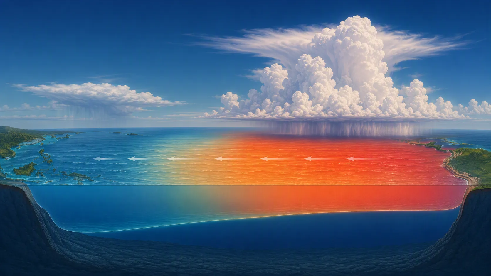
Normal tropical Pacific conditions give you the baseline. Easterly trade winds push warm surface water westward, so warm water piles up in the western Pacific. In the eastern equatorial Pacific, colder water can rise toward the surface through upwelling. That cold, nutrient-rich upwelled water helps support marine ecosystems off South America. The normal arrangement also helps place deep convection and heavy rainfall over the warmer western Pacific.[5][7][8]
During El Niño, those easterly trade winds weaken. The warm surface water spreads back toward the central and eastern equatorial Pacific. The eastern Pacific thermocline deepens, so cold nutrient-rich water is less able to reach the surface. Warmer surface water shifts the region of strongest convection eastward, and that disrupts the Walker circulation. The changed tropical heating pattern then helps alter jet-stream behavior and weather patterns far from the tropical Pacific.[7][8]
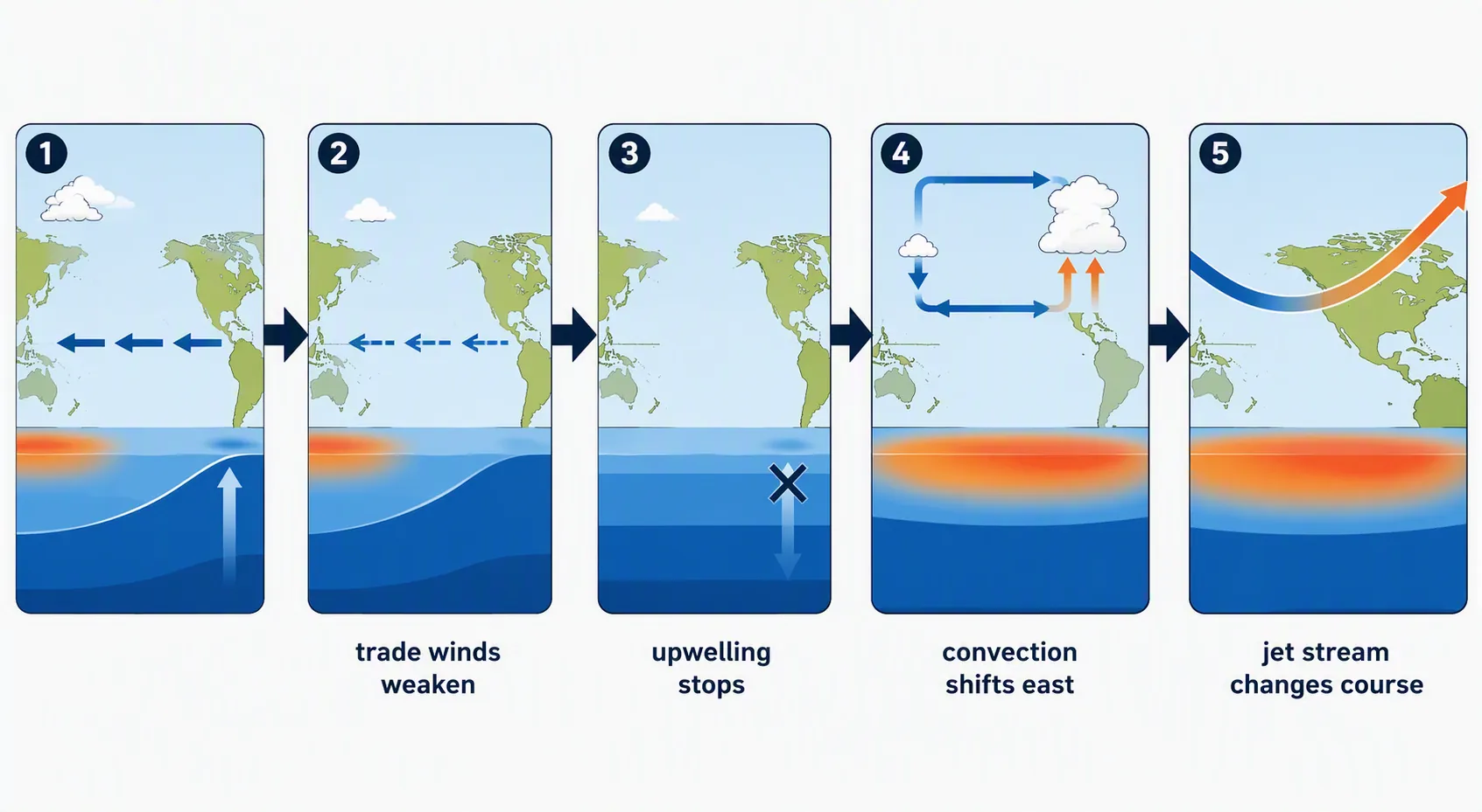
For a free-response answer, write the chain in order. Instructors can usually award more credit to a plain causal sequence than to a polished paragraph that jumps from “warm Pacific” straight to “weird weather.” A useful exam sentence is:
“During El Niño, weakened easterly trade winds allow warm surface water to spread east across the equatorial Pacific, reducing cold upwelling near South America; the warmer central/eastern Pacific shifts convection and the Walker circulation, which then affects jet-stream patterns and changes the probability of regional weather impacts.”
That one sentence contains the verbs that matter: weaken, spread, reduce, shift, affect. If your answer has only nouns — “warm water, Peru, rain, jet stream” — it is probably too list-like for a mechanism prompt.
How to handle the anchovy-and-agriculture prompt
Iowa State’s typical climate-variability exam questions include prompts such as “What is an El Niño and how does it affect global weather?” and “Why does El Niño simultaneously collapse the Peruvian anchovy fishery and Australian wheat production?”[5] The second question is not asking for two isolated facts. It is checking whether you can connect ocean mechanics to biological and agricultural consequences.
For Peru, start with reduced upwelling. Less cold, nutrient-rich water near the surface means less support for the food web that anchovies depend on. NOAA and other ENSO explainers describe the fishery collapse qualitatively; a frequently cited 50–80% decline estimate comes from a test-prep source rather than NOAA, so do not present that percentage as a NOAA measurement unless your course specifically supplies it. For Australia, connect the eastward shift of tropical convection to drier conditions in parts of the western Pacific region, which can stress crops such as wheat. The key is the shared driver: the coupled ocean-atmosphere shift, not two unrelated disasters.
U.S. winter impacts: learn the pattern, then say “more likely”
Weather exams like U.S. winter El Niño maps because they convert the tropical Pacific mechanism into something visible over North America. NOAA Climate.gov describes the main winter signal as a shifted jet stream and storm track: during El Niño winters, the southern tier of the United States is more likely to be cooler and wetter, while the northern tier is more likely to be warmer and drier.[1]
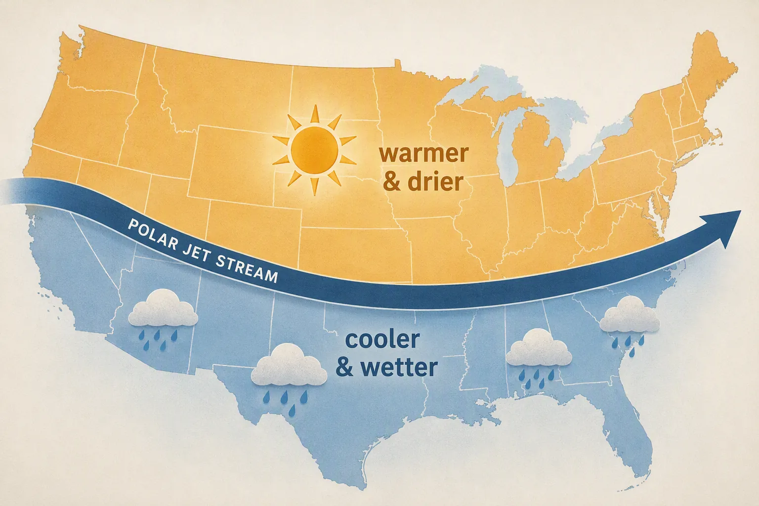
The grading word is “likely.” NOAA frames these impacts probabilistically, with typical patterns occurring about 40–80% of the time depending on the region and impact being discussed.[1] So the exam-safe version is not “El Niño makes California flood” or “El Niño makes all northern states dry.” It is: El Niño shifts the odds toward a cooler/wetter southern tier and a warmer/drier northern tier during winter.
That distinction matters because ENSO is one influence on seasonal patterns, not a daily forecast. A winter storm, a cold outbreak, or a wet month can still occur in a place whose seasonal odds lean the other way. If you have already studied atmospheric blocking or heat-dome-style persistence, the same exam habit applies: identify the large-scale setup, then avoid turning a probability into a guarantee. For more practice with that style of answer, compare the cause-and-effect framing in How a Heat Dome Forms for Weather Science Exams.
A clean winter-impact answer
If the prompt says, “Describe the typical effect of El Niño on U.S. winter weather,” write something close to this:
“El Niño changes tropical Pacific heating and tends to shift jet-stream and storm-track patterns. In winter, the southern United States is more likely to be cooler and wetter, while the northern United States is more likely to be warmer and drier. These are seasonal probability patterns, not guaranteed conditions for every location or storm.”
Hurricane-season questions: El Niño and La Niña flip the basin
Hurricane questions are often easier than winter-impact questions because the contrast is cleaner. El Niño tends to suppress Atlantic hurricane activity, partly through atmospheric conditions such as increased vertical wind shear over the Atlantic basin, while it tends to favor more tropical cyclone activity in the central and eastern Pacific. La Niña tends to reverse the pattern: more favorable Atlantic conditions and less favorable eastern Pacific conditions.[2][9]
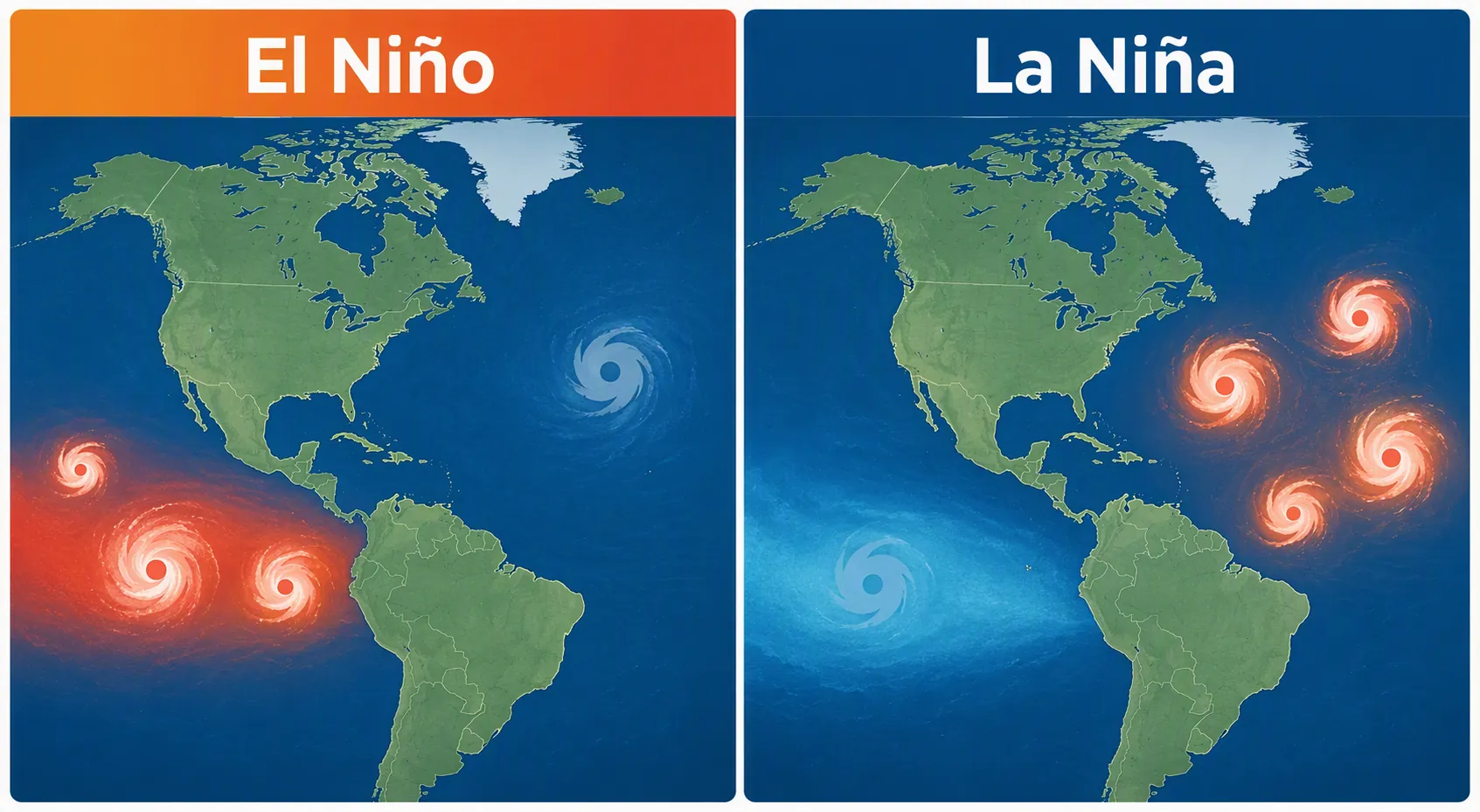
Do not answer this as “El Niño causes fewer hurricanes everywhere.” Basin matters. A correct multiple-choice option will usually specify the Atlantic or the central/eastern Pacific. If the option says “global hurricanes decrease,” be suspicious unless your course material has defined a very specific metric.
How often does El Niño happen?
Frequency is useful, but it is rarely the hardest part of the exam. Different NOAA and UCAR materials describe ENSO recurrence with slightly different ranges: NOAA Climate.gov and UCAR use about every 2–7 years, NOAA Education materials often say about every 3–5 years, and PMEL material gives about every 3–4 years in its FAQ context.[1][4][9] The safe study-sheet version is: El Niño is irregular, usually recurring every few years, often described in the 2–7 year range.
If your instructor wants a single number, use the one from lecture. If the exam gives choices, “irregular every few years” is better than treating El Niño as annual, random day-to-day weather, or a fixed calendar cycle.
Recurring exam formats and how to choose the best answer
Iowa State’s sample climate-variability questions and the Naval Postgraduate School ENSO self-test show the usual testing pattern: define El Niño, distinguish it from normal or La Niña conditions, explain the mechanism, identify regional impacts, and connect forecasts to planning decisions.[5][6] The questions are not trying to make you recite an encyclopedia entry. They are checking whether you can keep the ocean, atmosphere, and impact chain in the right order.
Format 1: “What is El Niño?”
Good enough for multiple choice: “the warm phase of ENSO.” Better for free response: “the warm phase of ENSO, marked by sustained anomalous warming in the Niño-3.4 region of the central/eastern equatorial Pacific and coupled changes in tropical atmospheric circulation.” Best if the prompt asks for measurement: add the +0.5°C, five-overlapping-season ONI rule, while noting that current operational monitoring has shifted toward RONI in 2026.
Format 2: “Explain the mechanism”
Start with normal trade winds, then weaken them. Do not begin with “it rains in California.” The mechanism answer should run from wind to water to upwelling to convection to circulation. If you have room, add jet-stream effects at the end. A common half-credit answer says only that warm water moves east. A full-credit answer explains why that changes upwelling and atmospheric convection.
Format 3: “Compare El Niño and La Niña”
| Feature | El Niño | La Niña |
|---|---|---|
| ENSO phase | Warm phase | Cool phase |
| Niño-3.4 sea-surface temperature anomaly | Warmer than average | Cooler than average |
| Trade winds | Weaken | Strengthen relative to normal |
| Eastern Pacific upwelling | Reduced | Enhanced |
| Convection | Shifts eastward | Tends to remain farther west |
| Atlantic hurricanes | Generally suppressed | Generally favored |
| Central/eastern Pacific hurricanes | Generally favored | Generally suppressed |
The table is not a substitute for the mechanism. It is a quick way to catch reversed answers. If an answer choice says El Niño strengthens easterly trade winds and increases eastern Pacific upwelling, it is describing the wrong side of the ENSO contrast.
Format 4: “How are El Niño forecasts used?”
Iowa State’s examples include questions about how El Niño forecasts are used in South America.[5] The answer should stay practical: forecasts help governments, fisheries, farmers, water managers, and emergency planners prepare for changed odds of drought, flooding, fishery disruption, or crop stress. Do not claim the forecast predicts every storm. Say it shifts seasonal risk planning.
That same habit helps on AP Environmental Science FRQs. If you need more practice turning environmental-science topics into scored response parts, the answer-logic approach in Agrivoltaics Study Guide for Environmental Science Exams uses a similar “identify, explain, apply” rhythm.
A short self-test before you close the tab
- Name the ENSO phase: El Niño is the warm phase; La Niña is the cool phase.
- Name the measurement region: Niño-3.4, located at 5°N–5°S and 120°W–170°W.
- State the classic ONI threshold: at least +0.5°C for five consecutive overlapping three-month periods, with atmospheric coupling.
- Explain the first physical change: easterly trade winds weaken.
- Follow the water: warm water spreads east and eastern Pacific upwelling is reduced.
- Follow the atmosphere: convection shifts east, the Walker circulation changes, and jet-stream patterns can shift.
- Give the U.S. winter pattern probabilistically: southern tier cooler/wetter is more likely; northern tier warmer/drier is more likely.
- Give the hurricane contrast by basin: El Niño suppresses the Atlantic and favors the central/eastern Pacific; La Niña tends to reverse that.
If you missed more than two of those, do not reread a long general explainer yet. Rewrite the mechanism chain from memory, then check it against your notes. If your exam is close, put ENSO into a short schedule rather than leaving it as “review climate chapter.” A planning template such as the Exam Countdown Study Planner Template can help you split definition drilling, mechanism practice, and map-impact review into separate sessions.
Broad ENSO explainers are worth reading when you have time. For exam points, though, study the repeatable pattern: define the index, describe the coupling, walk through the trade-wind and upwelling mechanism, then attach impacts as probabilities in the correct region and season.
References
- El Niño and La Niña: Frequently asked questions — NOAA Climate.gov
- Understanding El Niño & ENSO — NOAA
- El Niño and La Niña Years and Intensities (Oceanic Niño Index) — Golden Gate Weather Services
- El Niño, La Niña & ENSO FAQ — UCAR, December 2014
- Typical Exam Questions — Climate Variability — Iowa State University
- ENSO Self Test — Naval Postgraduate School
- El Niño / La Niña Basics — National Weather Service Fort Worth
- El Niño — National Geographic Education
- La Niña FAQs — NOAA Pacific Marine Environmental Laboratory
Related exhibits & inventory
Verified outcomes
No verified outcomes on file for this exam yet
See Methodology for how outcome evidence is disclosed once logged.
Planners
No planner filed for this exam yet
A downloadable timeline template for this exam hasn't been published yet.
Tool verdicts
AI-tool cautions
No AI tools tested for this exam yet
No hands-on AI-accuracy logs have been filed for this exam.
Questions about this plan
Ask a question about a specific section, timeline, or citation in this plan — or flag something that needs correcting.
Comments
Join the discussion with an anonymous comment.