
ASVAB Exam Hub
El Niño vs La Niña Study Guide for Kids
El Niño and La Niña are not separate events — they're opposite phases of the same Pacific Ocean pattern. This study guide explains the difference for middle-grades students with key vocabulary, a side-by-side comparison table, common misconception fixes, and a self-quiz with answer key.
- gre
- mcat
- asvab
- sat
- act
- digital-adaptive
- official-material
- section-strategy
- test-date-timeline
El Niño and La Niña are opposite phases of the same Pacific Ocean pattern, the El Niño–Southern Oscillation, or ENSO. They are sometimes compared to sibling opposites: closely related, but pulling the ocean-atmosphere system in different directions.[1][2] The analogy is useful as long as you remember that they are not independent characters—and one does not automatically cause the other.
To tell them apart on a test, begin with three pictures in your head: the normal tropical Pacific, that system with weaker trade winds, and that system with stronger trade winds. Once you can track where the warm water goes, you can reconstruct most of the comparison instead of memorizing disconnected facts.
Start with the normal Pacific “machine”
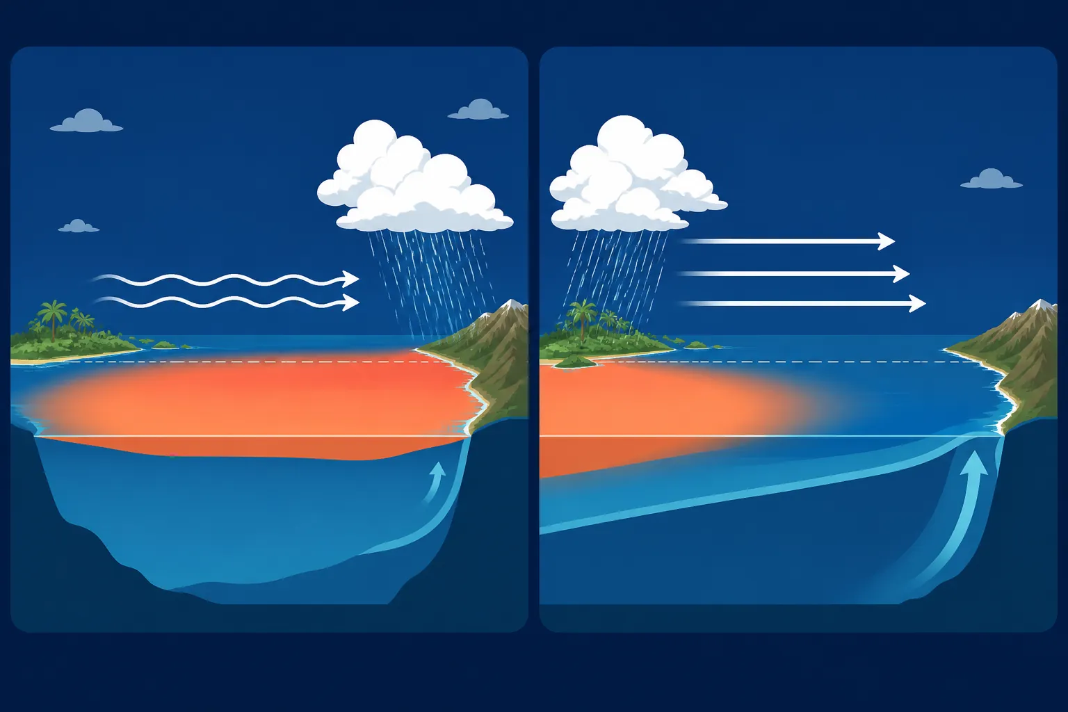
Under normal conditions, trade winds blow westward along the equator. They push warm surface water away from South America and toward Indonesia and the western Pacific. Because that surface water has moved west, colder water can rise from below near the west coast of South America. This rising water is called upwelling.[1]
The upwelled water carries nutrients that support tiny marine organisms and the food webs above them. Meanwhile, the warm western water adds heat and moisture to the air. Warm, moist air rises, so clouds and rain are generally concentrated near the warm-water pool.[1][3]
- Normal winds: trade winds blow westward.
- Warm water: piles up in the western tropical Pacific.
- Eastern Pacific: cold, nutrient-rich water rises near South America.
- Rain clouds: generally gather over or near the warmest water.
That last rule is a guide to the large-scale pattern, not a promise for every town. Mountains, coastlines, other climate patterns, and ordinary weather still affect where rain actually falls.
When the winds weaken: El Niño
During El Niño, the trade winds weaken. They no longer push warm surface water westward as strongly, so warm water spreads back toward the central and eastern equatorial Pacific. The eastern Pacific becomes warmer than average.[1][3]
With more warm water covering the eastern surface, cold-water upwelling near South America weakens. That can reduce the supply of nutrients reaching sunlit surface water, affecting plankton, fish, and the animals and people that depend on those food webs. The main zone of rising air, clouds, and tropical rainfall also shifts eastward with the warm water.[1][3]
Reconstruction shortcut: weaker winds → warm water moves east → less eastern upwelling → eastern Pacific warms.
When the winds strengthen: La Niña
During La Niña, the trade winds become stronger than normal. They push more warm surface water toward the western Pacific. Near South America, stronger upwelling brings more cold water toward the surface, making the central and eastern equatorial Pacific cooler than average.[2][4]
The warm-water pool and its main rain-cloud zone are held farther west. Stronger upwelling can also deliver more nutrients to eastern Pacific surface waters. This is the opposite physical flip from El Niño, although the effects are not perfectly mirrored in every place or season.[2][4]
Reconstruction shortcut: stronger winds → warm water pushed farther west → more eastern upwelling → eastern Pacific cools.
Key vocabulary
- ENSO: El Niño–Southern Oscillation, the connected ocean-atmosphere pattern that includes El Niño, La Niña, and neutral conditions.
- Trade winds: tropical winds that normally blow westward across the equatorial Pacific.
- Upwelling: the movement of colder, nutrient-rich water from deeper in the ocean toward the surface.
- Phase: one recognizable state of a repeating or shifting pattern. El Niño and La Niña are opposite ENSO phases.
- Temperature anomaly: the difference between an observed temperature and its long-term average. A positive anomaly is warmer than average; a negative anomaly is cooler than average.
- Neutral: the state in which the tropical Pacific does not meet the conditions used to identify El Niño or La Niña.
El Niño vs. La Niña comparison
| Feature | El Niño | La Niña | How to reconstruct it |
|---|---|---|---|
| ENSO phase | Warm phase | Cool phase | These are opposite phases of one Pacific pattern. |
| Trade winds | Weaker than normal | Stronger than normal | Ask how forcefully the winds are pushing surface water west. |
| Central and eastern equatorial Pacific | Warmer than average | Cooler than average | Weak winds allow warm water east; strong winds increase cold-water upwelling. |
| Upwelling near South America | Usually weaker | Usually stronger | More warm surface water suppresses upwelling; stronger westward winds help bring cold water upward. |
| Marine food webs in the eastern Pacific | Reduced upwelling can mean fewer nutrients at the surface | Stronger upwelling can bring more nutrients to the surface | Follow the cold, nutrient-rich water. |
| Typical U.S. winter pattern | The southern United States tends to be cooler and wetter; northern areas tend to be warmer | The southern United States tends to be warmer and drier; northern areas tend to be cooler and wetter | These are broad seasonal tendencies, not daily forecasts.[5] |
| Atlantic hurricane activity | Typically fewer hurricanes | Typically more hurricanes | ENSO changes atmospheric conditions that can suppress or support Atlantic hurricane formation.[5][8] |
The winter and hurricane rows describe changes in probability. A particular El Niño winter can depart from the typical pattern, and an individual storm cannot be explained by ENSO alone. For comparison with a shorter-lived atmospheric pattern, see how a heat dome forms.
Source-labeled fact sheet
| Testable fact | What the official sources say |
|---|---|
| Names | El Niño means “the little boy,” and La Niña means “the little girl” in Spanish. South American fishermen used El Niño for warm water noticed around Christmas.[5] |
| Usual duration | Episodes commonly last about 9–12 months. El Niño occurs more often, while some La Niña episodes continue for two years or longer.[5] |
| Recurrence | Official summaries give different broad estimates: NOAA Ocean Service says every 2–7 years, NOAA Climate.gov says every 3–7 years, and NOAA Education says every 3–5 years.[5][6][7] |
| El Niño historical benchmark | NOAA’s episode definition uses a sea-surface temperature anomaly of at least 0.5°C above average in a particular central Pacific region, maintained across five overlapping three-month periods.[6] |
| Longest episodes in the NOAA record cited | The longest El Niño lasted 18 months, while the longest La Niña lasted 33 months.[6] |
| Reliability of typical impacts | Depending on the particular impact, commonly described El Niño effects have historically occurred about 40%–80% of the time.[6] |
The recurrence estimates are not a countdown. ENSO does not arrive on a fixed schedule, and the source variation should not be “cleaned up” into one supposedly exact interval. If a test names a particular source, use that source’s range; otherwise, describe ENSO as irregular and occurring every few years.
Also keep the mechanism separate from the measurement rule. Warm water shifting east and weakening upwelling explains what El Niño physically does. The temperature threshold and five overlapping periods explain how NOAA identifies a sustained episode in its historical record. A brief warm fluctuation does not automatically become a full El Niño event.[6]
Common misconceptions that cause test mistakes
“El Niño is a storm that hits a place”
El Niño is not a storm with an eye, a track, or a landfall. It is a large-scale change in tropical Pacific ocean temperatures and the atmosphere above them. That change can influence weather patterns over many months and across distant regions.[6]
A sentence such as “El Niño hit California” therefore gives the wrong picture. A more accurate statement is that El Niño shifted the odds toward certain seasonal conditions, which may have influenced the weather experienced there.
“The typical effect must happen every time”
A typical effect is a tendency, not a guarantee. NOAA Climate.gov reports that commonly described El Niño impacts have occurred about 40%–80% of the time, depending on which impact is being examined.[6] That figure measures how often particular impacts accompanied past events; it does not mean that every location has one shared 40%–80% forecast.
This distinction matters in multiple-choice questions. Words such as “always,” “everywhere,” and “guarantees” are usually too strong. “Tends to,” “typically,” and “changes the likelihood” match the evidence more closely.
“La Niña is caused by El Niño”
La Niña may follow a strong El Niño, but scientists do not think it is always caused by the preceding El Niño.[9] ENSO can also return to neutral conditions. The safe relationship to remember is that El Niño and La Niña are opposite phases of the same coupled system—not an automatic cause-and-effect pair.
“Rain follows warm water, so every warm location gets rain”
At the scale of the tropical Pacific, the main zone of rising air and rain clouds generally shifts with the warm-water pool.[3][4] That is a powerful way to understand ENSO, but it is not a universal local forecast. Local rainfall still depends on atmospheric circulation, geography, season, and other weather patterns.
Self-quiz
- What does ENSO stand for, and how are El Niño and La Niña related to it?
- In the normal tropical Pacific, which direction do the trade winds push warm surface water?
- What is upwelling, and why does it matter to marine life?
- The trade winds weaken, warm water spreads eastward, and upwelling near South America decreases. Which ENSO phase is this?
- The trade winds strengthen and the central and eastern equatorial Pacific become cooler than average. Which phase is this?
- Which phase is typically associated with fewer Atlantic hurricanes: El Niño or La Niña?
- Why is “El Niño hit the coast” an inaccurate statement?
- True or false: A strong El Niño must be followed by La Niña.
- Without looking back, reconstruct both flips from this starting fact: normal trade winds push warm Pacific surface water westward.
Answer key
- ENSO stands for El Niño–Southern Oscillation. El Niño is its warm phase, and La Niña is its cool phase.
- Westward, toward Indonesia and the western Pacific. That movement helps make room for cold-water upwelling near South America.
- Upwelling is the rise of colder water from below. It matters because that water carries nutrients that support marine food webs.
- El Niño. Weaker winds allow warm water to spread east and reduce eastern Pacific upwelling.
- La Niña. Stronger winds push warm surface water farther west and strengthen the rise of colder water in the east.
- El Niño is typically associated with fewer Atlantic hurricanes. This is a seasonal tendency, not a guarantee.
- El Niño is a broad ocean-atmosphere pattern, not an individual storm that has a track or makes landfall.
- False. La Niña may follow a strong El Niño, but that sequence is neither automatic nor always a direct cause-and-effect relationship.
- El Niño: winds weaken, warm water spreads east, eastern upwelling weakens, and the eastern equatorial Pacific warms. La Niña: winds strengthen, warm water is pushed farther west, eastern upwelling strengthens, and the eastern equatorial Pacific cools.
If you want digital review cards, the compact facts and reconstruction arrows can be turned into flashcards with the NotebookLM guide for students. The most important test is whether you can cover the comparison table and rebuild both phases from the normal Pacific pattern.
References
- What Is El Niño? — NOAA SciJinks
- What Is La Niña? — NOAA SciJinks
- What Is El Niño? — NASA Space Place
- What Is La Niña? — NASA Space Place
- What are El Niño and La Niña? — NOAA Ocean Service
- El Niño and La Niña Frequently Asked Questions — NOAA Climate.gov (archived snapshot dated June 25, 2025)
- El Niño — NOAA Education
- El Niño and La Niña — Met Office
- What is El Niño? — NOAA Pacific Marine Environmental Laboratory
Related exhibits & inventory
Verified outcomes
No verified outcomes on file for this exam yet
See Methodology for how outcome evidence is disclosed once logged.
Planners
No planner filed for this exam yet
A downloadable timeline template for this exam hasn't been published yet.
Tool verdicts
AI-tool cautions
No AI tools tested for this exam yet
No hands-on AI-accuracy logs have been filed for this exam.
Questions about this plan
Ask a question about a specific section, timeline, or citation in this plan — or flag something that needs correcting.
Comments
Join the discussion with an anonymous comment.