
Method
How amateur astronomers find meteor craters using Google Maps
Learn how amateur astronomers use Google Maps and Google Earth Pro to systematically search for unrecorded impact craters, identify key visual signatures, avoid false positives, and report candidates through the proper scientific pipeline.
Evidence panel
- Evidence level
- Moderate
- Primary citation
- USGS, 'How can I tell if I have found an impact crater?'
Last reviewed: July 23, 2026.
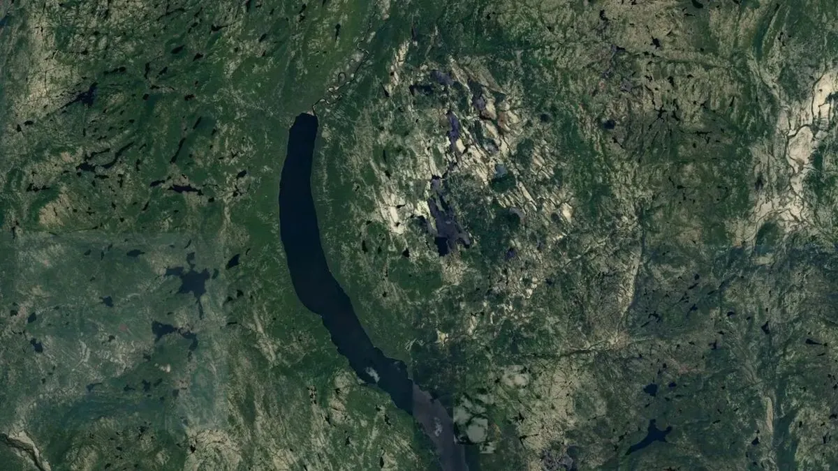
An amateur really can start a meteor-crater discovery with Google Maps. Joël Lapointe did it while planning a camping route in Quebec: he noticed an almost circular, roughly 25-kilometer ring around Lake Marsal, checked that it was not already listed in crater databases, and contacted scientists who could evaluate it properly.[1] That sequence matters more than the lucky first glance. The useful lesson is not “circle equals crater.” It is: notice, measure, compare, document, and then hand the claim to people who can test rocks.
The Lake Marsal structure, now named Uhackatik with the Innu Council of Ekuanitshit, is the sort of case that keeps careful amateurs looking. A later field expedition found shatter cones visible to the naked eye and cliffs of impact melt rock, and the structure has been reported as about 390 million years old.[2] Those are not details a laptop can supply. They are the difference between a promising image and a scientific crater candidate.
The field is still open enough to reward attention. The Earth Impact Database listed 190 confirmed terrestrial impact craters as of November 2025, with Canada having 31, the most of any country.[3] New confirmations are uncommon, not because Earth stopped being hit, but because erosion, burial, vegetation, oceans, ice, and later volcanism all hide the signal.
Start With Google Maps, But Do Not Stay There
Google Maps is good for broad scanning. Open satellite view, zoom slowly across remote or poorly mapped terrain, and look for large circular or ring-shaped landforms that appear coherent across forest, lakes, drainage, and topography. If terrain display is available, turn it on; if it is not, do not improvise confidence from a flat image. Move the candidate into Google Earth Pro on desktop, which is free and better suited to serious inspection because it gives you reliable ruler tools, elevation reading, historical imagery where available, and 3D terrain viewing.
The first notebook entry should be dull and exact. Record the coordinates, the apparent diameter, the direction of lighting in the image, the date of the imagery if visible, the map scale used, and what made you stop. A good candidate file is not a screenshot with an arrow. It is a record someone else can reopen, measure, and criticize.
- Use Google Maps satellite view for the first sweep, not for a final claim.
- Open the same coordinates in Google Earth Pro before judging relief, rim continuity, or possible central uplift.
- Measure the feature in at least two directions; an apparent circle may become an oval once measured.
- Save screenshots at different zoom levels so the feature is shown in regional context, not just as a cropped ring.
- Write down nearby roads, rivers, quarries, volcanic fields, mines, salt structures, glaciers, coastlines, or other obvious geological clues.
This is where amateur astronomy becomes something closer to remote geological mapping. The same patience used for observing logs still helps: do not trust one view, one night, one scale, or one exciting outline.
What a Satellite Image Can Suggest
On imagery, the most tempting sign is circularity. It is also the weakest sign. A crater candidate becomes more interesting when the circular outline is paired with topographic structure: a raised rim, a basin-like depression, a ring pattern that cuts across ordinary drainage, or a possible central uplift in larger structures. Even then, the language should stay provisional: “circular depression with possible raised rim,” not “meteor crater.”
| Feature to note | What to look for in free imagery | How cautious to be |
|---|---|---|
| Circular or ring-shaped outline | A rim or ring that remains visible across several zoom levels and image dates | Very cautious; many Earth processes make circles |
| Raised rim | Higher ground around a depression, best checked in Google Earth Pro 3D view | Useful if continuous, but not diagnostic |
| Central uplift possibility | A central high area inside a larger circular structure | Interesting in complex craters, but must be measured against regional geology |
| Radial or disturbed drainage | Streams bending around or cutting through a circular feature | Can support mapping, but drainage adapts to many landforms |
| Exposed rock | Cliffs, outcrops, quarry faces, or shorelines where field geologists might inspect material | Important for follow-up, not proof from orbit |
The best image work slows you down. Trace the possible rim. Check whether lakes merely happen to form a rough circle. Rotate the Google Earth Pro view and exaggerate terrain only as an inspection aid, not as evidence. Ask whether the ring survives when you zoom out far enough to see the surrounding geological province. Many false candidates look impressive only when cropped.
For a hypothetical example, suppose you find a round lake with a bright shoreline and forested high ground around it. That is a reason to measure, not a reason to report. If nearby hills share the same curved shape, if the shoreline follows bedrock layering, or if the depression aligns with glacial erosion, the “crater” may already be explaining itself without an impact.
The False-Positive Filter Is the Main Work
The U.S. Geological Survey gives the necessary warning plainly: many natural processes other than impacts can create circular features.[4] That sentence should sit beside the search window. Volcanoes, glacial cirques, sinkholes, salt domes, atolls, hydrothermal explosions, mines, and other processes can all produce shapes that look crater-like from above.[4]
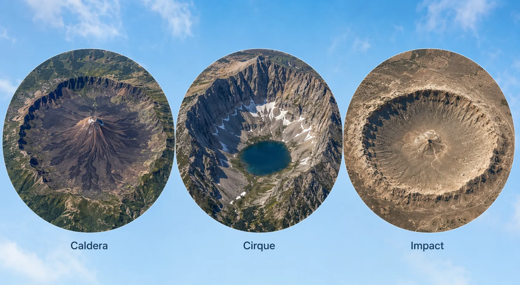
This is the point where most online crater claims go wrong. A circular lake in volcanic terrain should first make you think of a caldera or maar. A bowl at the head of a mountain valley should make you think of glacial erosion. A round depression in limestone country raises sinkholes. A ring near a coast may be biological or sedimentary. A suspiciously regular hole with roads, benches, or spoil piles may be a mine.
- Volcanic caldera: look for lava flows, cones, ash deposits, or a wider volcanic field.
- Glacial cirque: look for steep amphitheater walls at the head of a valley and other glacial landforms nearby.
- Sinkhole or karst basin: look for soluble rock regions, clustered depressions, and irregular drainage.
- Salt dome or structural basin: look for regional geological patterns that repeat beyond the candidate.
- Mine or quarry: look for roads, terracing, tailings, rectangular infrastructure, or recent imagery changes.
- Atoll or reef structure: look for shallow marine setting and biological carbonate geometry rather than excavated relief.
Gordon Osinski, director of Impact Earth at Western University, has said that roughly 99 out of 100 reported candidates are false positives.[2] That is not an insult to amateurs. It is a reminder that the first job is subtraction. Each plausible non-impact explanation you eliminate makes the remaining case cleaner; each one you ignore transfers work to someone else.
Cross-Reference Before You Contact Anyone
Lapointe’s useful move was checking crater databases before contacting experts.[1] Do the same. Search the Impact Earth map from Western University, the Earth Impact Database, and the Lunar and Planetary Institute’s terrestrial crater map before writing an email.[3][5][6] If a structure is already confirmed, already rejected in accessible literature, or already mapped as a volcano, basin, mine, or karst feature, your report should change accordingly.
- Search the candidate coordinates in the Impact Earth crater map and nearby confirmed structures.[5]
- Check the Earth Impact Database list and map context for confirmed craters and naming conventions.[3]
- Use the LPI terrestrial impact crater map as another visual cross-check, especially for regional pattern recognition.[6]
- Search the feature name, lake name, mountain name, or local administrative area with geology terms such as “caldera,” “karst,” “salt dome,” “mine,” or “glacial.”
- Keep a written log of negative checks; “not found in database” is more credible when the exact databases and dates are recorded.
A candidate that survives these checks is still only a candidate. Satellite imagery can help locate a target and assemble a disciplined question. It cannot show shocked quartz in a thin section, identify high-pressure mineral polymorphs, or prove an impactor’s geochemical signature.
What Actually Confirms an Impact Crater
The Planetary and Space Science Centre at the University of New Brunswick sets a high bar for adding or evaluating a proposed crater. Its reporting guidance says that all, or at least 80 percent, of the required criteria should be met and supported by peer-reviewed data before a site is evaluated.[7] That requirement is stern because it has to be. PASSC also says it receives about three crater reports per week and has “a cabinet full of files for potential craters” that could not be confirmed because resources were not available.[7]
The diagnostic evidence is geological. Shatter cones are especially valuable because they can be visible in the field and are considered uniquely diagnostic of impact. Other confirmation criteria include planar deformation features in quartz, impact melt rock, impact breccia, pseudotachylyte, high-pressure mineral polymorphs such as coesite and stishovite, and geochemical signatures of an impactor.[7]
| Evidence type | Where it is found | Why a map user cannot confirm it alone |
|---|---|---|
| Shatter cones | Rock outcrops in the field | They require field inspection and correct geological identification |
| Planar deformation features in quartz | Microscope work on mineral grains | They require prepared samples and expert analysis |
| Impact melt rock | Melt-bearing outcrops or samples | It must be distinguished from volcanic or other melted material |
| Impact breccia | Broken and re-cemented rock units | Breccia can form in several non-impact settings |
| High-pressure minerals | Laboratory-identified mineral phases | They require mineralogical testing |
| Geochemical impactor signature | Rock chemistry | It requires lab data and comparison with background composition |
Uhackatik illustrates the divide neatly. The Google Maps ring started the question. The expedition and rock evidence carried it forward. Osinski described the October 2025 field trip as “one of the most arduous expeditions I’ve ever done — 25 Arctic expeditions and 6 continents,” and that expedition found visible shatter cones and 50-meter cliffs of impact melt rock.[2] The romance of the story is real, but it is not located only in the screenshot. It is also in the hard, wet, slow work that followed.
A Responsible Candidate Report
If a feature survives your first-pass checks, write a report that makes it easy to reject, refine, or escalate. That sounds severe, but it is considerate. A scientist or database curator should not have to reconstruct your search path from scattered screenshots.
- Coordinates in decimal degrees and a clear location description.
- Diameter measurements in multiple directions, with the tool and imagery source noted.
- Screenshots from Google Maps and Google Earth Pro at regional, local, and close scales.
- Observed landform features: rim, depression, ring structure, possible central uplift, drainage pattern, exposed rock.
- False-positive checks already considered, including volcanic, glacial, karst, salt, reef, hydrothermal, mining, or other local explanations.
- Database checks performed, including the date checked and whether the feature appeared in Impact Earth, the Earth Impact Database, or the LPI map.
- Any geological maps, papers, or local place-name sources you consulted, with links or citations.
Avoid dramatic subject lines and certainty. “Possible circular impact structure candidate near [location], with database checks attached” is more useful than “New meteor crater discovered.” If you have no field samples, say so. If you are not trained in geology, say so. Honest limits make the report easier to trust.
Also respect land, people, and names. Uhackatik was named with the Innu Council of Ekuanitshit.[1] A remote feature on a satellite image is not empty space; it may be Indigenous land, protected land, private land, or an area with existing local names and histories. Do not plan field visits, sampling, or publicity as if coordinates erase responsibility.
Where the Amateur Contribution Really Fits
The strongest amateur contribution is not confirmation. It is disciplined noticing. Free satellite imagery lets a patient observer find patterns across huge landscapes, especially in regions where few people have looked carefully for impact structures. Google Maps can start the trail; Google Earth Pro can sharpen the observation; public databases can prevent duplicate or careless claims; geological evidence decides the matter.
That is a good methods lesson beyond crater hunting. Pattern recognition is only the beginning of evidence. The study habit that matters is grading the observation: what did you see, what else could explain it, what source would disprove it, and what evidence would move it from interesting to credible?
Lapointe’s discovery is encouraging precisely because it was not just a lucky circle on a screen. It was a hunch followed by database checks, expert contact, fieldwork, and diagnostic rock evidence. That is how amateur astronomers can use Google Maps to look for meteor craters without turning every round lake into a burden on science.
References
- An Amateur Astronomer Using Google Maps Spotted a Strange Indentation. It Turned Out to Be a Meteorite Crater From 390 Million Years Ago, Smithsonian Magazine
- ‘This was one of the most arduous expeditions I’ve ever done’: Scientists confirm that 15-mile-wide pit found on Google Maps is ancient meteor crater, Live Science
- Earth Impact Database, Wikipedia
- How can I tell if I have found an impact crater?, U.S. Geological Survey
- Impact Craters Map, Impact Earth, Western University
- Terrestrial Impact Craters, Lunar and Planetary Institute
- Report a New Impact Crater, Planetary and Space Science Centre, University of New Brunswick
Applies to
Exam applicability isn't specified for this technique yet. See all exam hubs.
Comments
Join the discussion with an anonymous comment.