
ASVAB Exam Hub
How to Spot Impact Craters on Google Earth for Study
This step-by-step guide teaches earth science students how to reliably find and verify impact craters using Google Earth's Terrain layer, the Ruler tool, and the Earth Impact Database—because most circular features spotted on satellite imagery turn out to be geological false positives.
- SAT
- ACT
- GRE
- MCAT
- ASVAB
- digital-sat
- adaptive-testing
- registration-fee
- content-outline
- score-target
Joël Lapointe did the thing every Google Earth crater hunter hopes to do: he noticed a huge, nearly circular feature in remote Quebec while looking at map imagery. The feature, now discussed as the Uhackatik structure, is about 25 kilometers across, and Lapointe reported it through Impact Earth at Western University after spotting it in 2024.[1][2] That first map observation mattered. It was not the proof.
The proof came later, when researchers reached the site and found field evidence: shatter cones and impact melt rock. Reports published after the October 2025 expedition describe the structure as a confirmed ancient meteor crater, dated to about 390 million years old.[2][3] That sequence is the lesson. Google Earth can help you find and study a candidate. It cannot, by itself, confirm an impact crater.
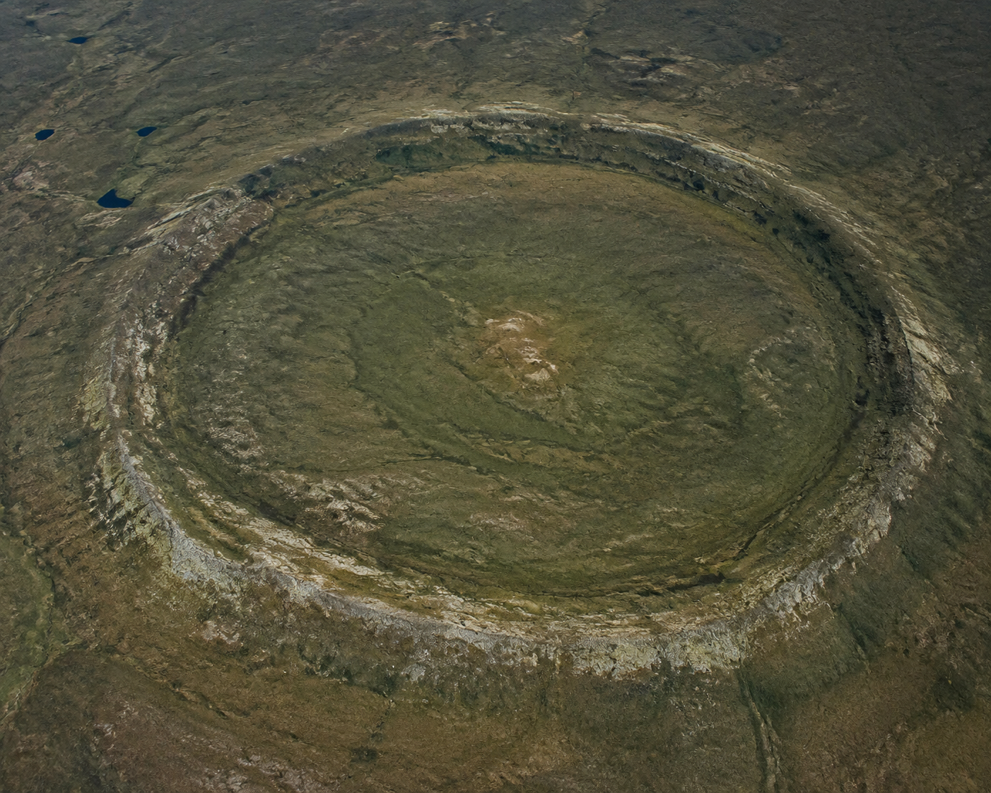
If you are learning how to spot craters on Google Earth for study, the useful goal is not to collect perfect circles. The useful goal is to produce a clean candidate note: where the feature is, how large it is, what its relief looks like, whether it already appears in a confirmed database, and which non-impact explanations you considered before you got excited.
That caution is not academic fussiness. Planetary geologist Gordon Osinski has estimated that 99 out of 100 publicly reported circular crater-like features turn out not to be impact structures.[2] Smithsonian’s account of the Uhackatik story gives the same warning in looser terms, noting that most suspected discoveries are false alarms.[3] Once you have graded enough round lakes, eroded domes, calderas, salt structures, and glacial features, that estimate stops sounding harsh and starts sounding merciful.
Start with relief, not the prettiest circle
Open Google Earth and make the Terrain layer part of the observation, not an afterthought. Google Earth is useful for teaching and spatial investigation because it lets students move between imagery, terrain, placemarks, and measurement rather than treating a satellite image as a flat picture.[4] For crater study, that matters because a circular color patch is usually the least trustworthy part of the scene.
A candidate worth slowing down for should show some kind of three-dimensional structure: a raised rim, a depressed interior, disrupted drainage, a central uplift in larger complex craters, or a ring pattern that holds up when you tilt the view and change scale. None of those features confirms an impact. They simply move the feature from “round thing” to “worth measuring.”
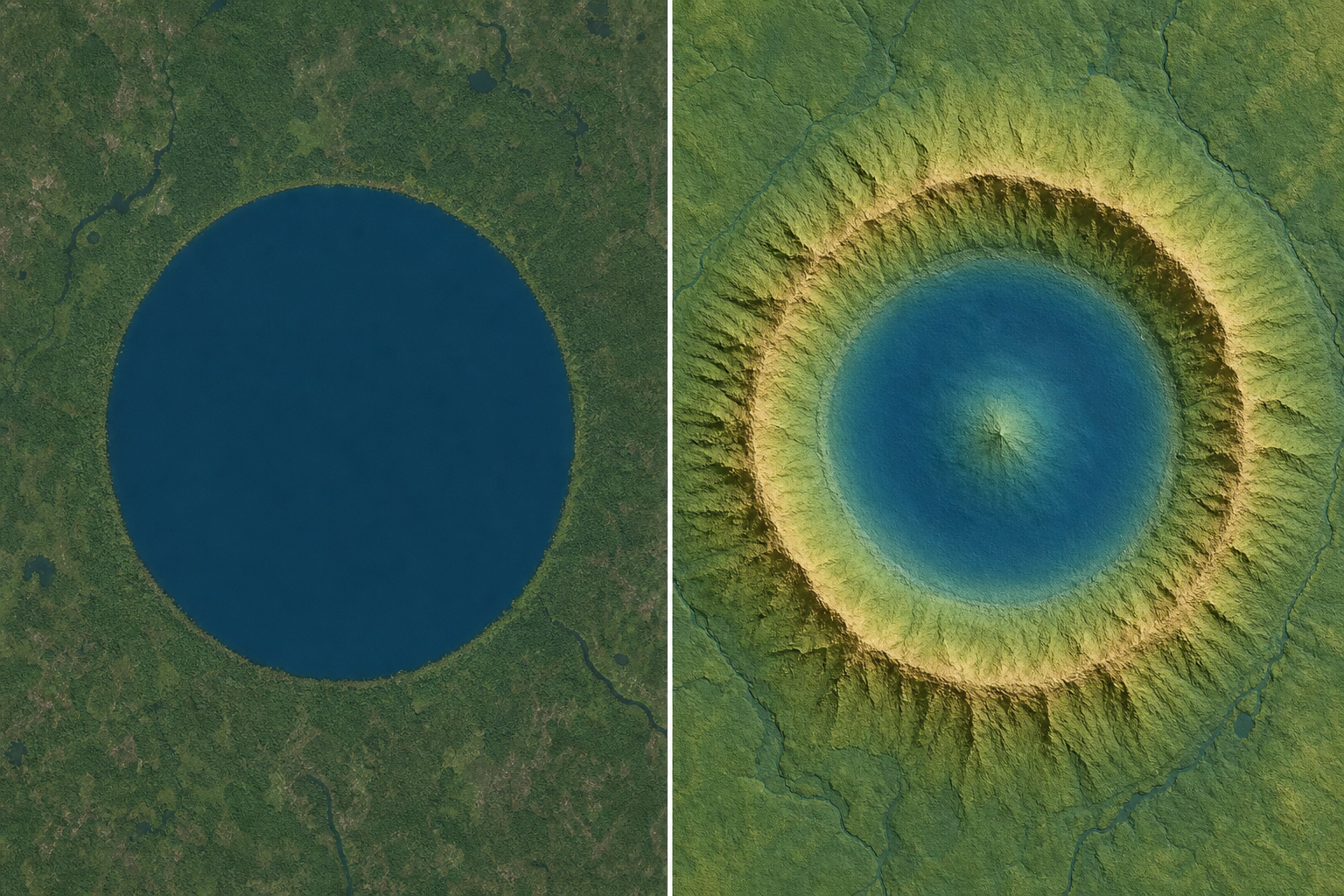
Do not judge the feature from directly overhead only. Tilt the view. Rotate it. Zoom out until you can see the regional setting, then zoom back in until the rim or depression stops being obvious. A real structure should not depend on one lucky viewing angle or one image color boundary. Many false positives look convincing only because a lake shoreline, vegetation change, snow edge, or shadow happens to trace a curve.
At this point, write observations, not conclusions. “Circular lake with possible raised western rim” is useful. “Impact crater” is not. If you are preparing for an earth science class or an ASVAB General Science review session, this distinction is the skill: observation first, interpretation later.
Measure the candidate before naming it
Once the feature survives the first terrain check, measure it. The Down2Earth crater-measuring worksheet uses Google Earth’s Ruler tool for exactly this kind of exercise: students measure crater diameters directly in Google Earth rather than estimating size by eye.[5] That is a small step, but it cleans up a surprising amount of bad reasoning.
- Set the view so the whole candidate is visible and the rim, depression, or ring boundary is as clear as possible.
- Open the Ruler tool and choose a distance unit you will use consistently, usually kilometers for large terrestrial structures.
- Measure rim to rim across the widest convincing diameter.
- Measure a second diameter roughly perpendicular to the first.
- Record both values instead of forcing the feature into one neat number.
That second measurement matters. Impact structures can be modified by erosion, burial, tectonics, sediment fill, ice, or later drainage, so they do not need to be mathematically perfect circles. But if your “crater” becomes a long oval when measured in two directions, the honest description changes. You may still have a geological feature worth studying, but you have weaker evidence for a crater-shaped impact structure.
Also measure what you think you are measuring. A lake inside a structure is not automatically the crater diameter. A vegetation ring may be smaller than the structural rim. A drainage basin may be larger than the original feature. When students skip this distinction, the number in the report looks precise but describes the wrong thing.
| What you see | What to record | Why it matters |
|---|---|---|
| Outer raised rim or ring | Possible structural diameter | Best first estimate if the rim is continuous enough to trace |
| Lake inside a circular basin | Water-body diameter and separate basin diameter if visible | The lake may be smaller than the crater structure |
| Circular color or vegetation boundary | Boundary diameter with a note that relief is uncertain | Color boundaries can come from soil, moisture, snow, vegetation, or land use |
| Broken or eroded arc | Diameter estimate from the visible arc, marked as approximate | Partial rings are common in old terrain but easy to over-interpret |
For a class assignment, keep the measurement trail simple enough that someone else could repeat it. Include coordinates, the two diameter measurements, the feature you treated as the rim, and a screenshot if allowed. A repeatable imperfect measurement is better than a dramatic label with no method behind it.
Check confirmed crater databases before chasing a discovery
After measuring, cross-check the location against confirmed impact crater resources. The USGS explicitly points readers to the Planetary and Space Science Centre at the University of New Brunswick for impact crater confirmation, rather than presenting itself as the confirmation authority.[6] That detail is worth respecting. Confirmation belongs to evidence and specialist review, not to whoever first noticed a ring on a screen.
Start with the Earth Impact Database maintained through PASSC/UNB. It is the standard place to check whether a terrestrial structure is recognized as confirmed, and PASSC describes its work around Earth impact structures and planetary geology.[7] Public summaries of the list show roughly 200 confirmed impact structures on Earth, with Canada especially well represented because old, stable bedrock preserves ancient structures well.[8]
Then compare your candidate with mapped resources. Western University’s Impact Earth map gives students a practical way to browse known impact structures spatially.[9] LPI also provides impact crater KMZ resources for Google Earth-based exploration, though access to some resource pages may require authentication.[10] These tools are not decorative overlays. They are a way to find out whether your candidate is already known, whether a confirmed crater nearby has similar scale or morphology, and whether your interpretation is drifting away from the evidence.
The database step has three possible outcomes, and only one of them feels instantly satisfying:
- The feature matches a confirmed impact structure: your job becomes a study report, not a discovery claim.
- The feature is near a confirmed structure but does not match it: check your coordinates, scale, and rim interpretation before assuming anything new.
- The feature is absent from confirmed lists: treat it as unconfirmed and move to impostor testing, not announcement.
This is where many reports go wrong. A database miss does not make a candidate more exciting by default. It usually makes the burden of evidence heavier.
Test the impostors on purpose
A round landform can be real, interesting, and completely unrelated to an impact. That is not a consolation prize; it is geology behaving normally. Before you write up a candidate as “possible impact,” try to make the non-impact explanations win.
| Possible impostor | Google Earth clue to inspect | What weakens the impact interpretation |
|---|---|---|
| Volcanic caldera or crater | Nearby lava flows, volcanic cones, volcanic terrain patterns | The ring fits a volcanic field better than an isolated impact structure |
| Glacial lake or kettle feature | Regional pattern of lakes, scoured bedrock, moraines, ice-shaped drainage | The circle is one of many ice-related depressions |
| Eroded dome or structural basin | Concentric bedrock patterns, long regional folds, drainage following rock layers | The feature belongs to a broader structural trend |
| Salt dome or collapse feature | Circular depression with surrounding sedimentary patterns | The form can arise from subsurface movement or dissolution |
| Human-made reservoir, mine, or excavation | Roads, dams, benches, spoil piles, geometric edges | The outline is engineered rather than geological |
You do not need to identify the correct impostor with certainty for a student report. You do need to show that you looked. If the feature sits among many similar lakes, say so. If the “rim” lines up with regional ridges, say so. If the apparent circle disappears when the terrain is tilted, say so. Those notes are not failures; they are the part of the method that prevents a false positive from becoming a story.
Uhackatik is useful here because it did not stop at map shape. The later reports emphasize field evidence—especially shatter cones and impact melt rock—as the confirmation markers visible without requiring a microscopy lesson.[2][3] In a classroom or self-study setting, you can recognize what those markers mean without pretending you can see them from orbit.
Write the candidate report like a scientist, not a treasure hunter
A good crater study report is plain. It should let another reader follow your path from image to measurement to database check to uncertainty. The stronger your candidate, the less it needs inflated language.
- Location: coordinates, region, and a short note on terrain setting.
- Observed morphology: rim, depression, central uplift if present, drainage, ring continuity, and what changes when the view is tilted.
- Measurements: at least two diameters with units and a note on what boundary was measured.
- Database check: whether the feature appears in the Earth Impact Database, Impact Earth map, or KMZ crater resources.
- Impostor check: the strongest non-impact explanations you considered.
- Status: confirmed, likely false positive, or unconfirmed candidate worth expert review.
Use the word “confirmed” only when the structure is already recognized by a reliable crater database or supported by field evidence reported through scientific channels. If your evidence is limited to Google Earth, the honest status is “candidate” or “possible circular structure,” not “new crater.”
For study purposes, that is enough. A measured, cross-checked false positive can teach more earth science than an overconfident crater claim. The finished product should make clear whether the feature is confirmed, probably not an impact, or sufficiently unusual that someone with field access and geological expertise would need to examine it.
References
- A massive crater was spotted on Google Earth. It could be a scar from an ancient meteorite impact, Space.com
- Scientists confirm that 15-mile-wide pit found on Google Maps is ancient meteor crater, Live Science
- An Amateur Astronomer Using Google Maps Spotted a Strange Indentation. It Turned Out to Be a Meteorite Crater From 390 Million Years Ago, Smithsonian Magazine
- User Guide - Teaching with Google Earth, SERC Carleton
- Measuring impact craters on the Earth, Down2Earth
- How can I tell if I have found an impact crater?, USGS
- PASSC, University of New Brunswick
- List of impact structures on Earth, Wikipedia
- Impact Earth Database, Western University
- LPI Impact Craters KMZ files, Lunar and Planetary Institute
Related exhibits & inventory
Verified outcomes
No verified outcomes on file for this exam yet
See Methodology for how outcome evidence is disclosed once logged.
Planners
No planner filed for this exam yet
A downloadable timeline template for this exam hasn't been published yet.
Tool verdicts
AI-tool cautions
No AI tools tested for this exam yet
No hands-on AI-accuracy logs have been filed for this exam.
Questions about this plan
Ask a question about a specific section, timeline, or citation in this plan — or flag something that needs correcting.
Comments
Join the discussion with an anonymous comment.