
ACT Exam Hub
Find Meteorite Craters on Google Earth for Your Science Project
Learn how to use Google Earth to systematically search for and document meteorite impact craters for a science project. This guide covers the terrain overlay method, four key recognition criteria, and how to cross-reference candidates against known impact databases.
- SAT
- ACT
- GRE
- MCAT
- ASVAB
- digital-sat
- adaptive-testing
- registration-fee
- content-outline
- score-target
Could you really find a meteorite crater on Google Maps or Google Earth for a science project? Yes, in the careful, slightly less glamorous sense of the word “find.” In 2024, amateur astronomer Joël Lapointe noticed an unusually round structure in Quebec while using Google Maps. Scientists later investigated the site, now called the Uhackatik impact structure, and reporting in July 2026 described it as about 25 kilometers wide and roughly 390 million years old.[1] Fieldwork did the hard part: researchers found shatter cones and impact melt rock during an October 2025 expedition co-led by Gordon Osinski, evidence that satellite imagery alone cannot provide.[2]
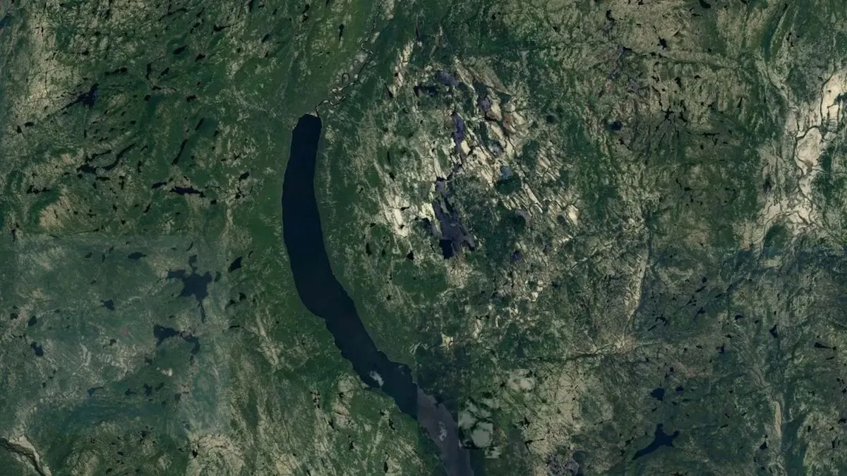
That is the exciting part. Now for the part that makes the project scientific: your Google Earth work can identify a candidate, compare it with known craters, and explain why similar-looking features may not be impact structures. It cannot confirm a new crater from your laptop. Confirmation requires physical evidence in rocks, and some sites are on Indigenous, private, protected, or dangerous land. The Uhackatik expedition, for example, involved consultation with the Innu Council of Ekuanitshit.[1]
For a school project, that limitation is not a disappointment. It gives you a better project. A labeled screenshot, coordinates, a diameter measurement, terrain observations, and a false-positive check will beat a giant claim almost every time.
What Google Earth Can Show, And What It Cannot
Impact craters are rare on Earth because erosion, plate tectonics, vegetation, oceans, and later sediment can hide or destroy them. Osinski told Live Science that only about 200 confirmed impact craters are known on Earth, and that roughly one or two new ones are confirmed each year.[2] That number should change how you look at every attractive circle on the screen. Most circles are not meteorite craters.
The most important difference is between a visual clue and evidence. A circular lake may be a clue. A raised rim may be a better clue. But confirmation depends on diagnostic shock features in the rocks. The U.S. Geological Survey notes that evidence for an impact crater includes features such as shatter cones, shocked minerals, and impact melt rocks, not just a round shape seen from above.[3]
Shatter cones are especially worth knowing by name. They are cone-shaped fracture patterns that can be seen with the naked eye in rocks and are widely treated as strong evidence of shock from an impact.[3] In the Uhackatik case, the map started the question, but field evidence carried the answer.[2]
A Responsible Workflow For A Crater-Search Project
Use Google Earth rather than relying only on Google Maps. Maps is fine for noticing a shape, but Google Earth gives you better control over terrain, coordinates, historical imagery in some areas, and measuring tools. Your goal is not to roam randomly until something looks dramatic. Your goal is to build a small, repeatable investigation.
| Stage | What You Do | What You Produce |
|---|---|---|
| Train your eye | Load or view confirmed crater locations before searching for unknown-looking features. | A short comparison sheet of real craters. |
| Scan with terrain visible | Search stable old bedrock regions and keep relief turned on. | Screenshots of possible candidates with coordinates. |
| Apply visual criteria | Check circularity, rim relief, central uplift, and drainage disruption. | A notes table, not just a pretty image. |
| Measure | Use the ruler tool to estimate diameter and compare the feature with its surroundings. | Diameter, scale, and map-view evidence. |
| Cross-reference | Check known-crater databases and map viewers. | A candidate status: known crater, likely false positive, or uncertain candidate. |
| Write the claim carefully | State what your evidence can and cannot show. | A science-project conclusion with uncertainty. |
Start With Known Craters Before Hunting For New Ones
Before searching, spend time with confirmed craters. Load a crater overlay if you have one available, or use online crater maps alongside Google Earth. The Earth Impact Database, maintained by the Planetary and Space Science Centre at the University of New Brunswick, is a major reference for confirmed terrestrial impact structures, though its public site shows a 2018 update date.[4] Because of that age, treat it as important but not your only check.
Also compare with the Impact Earth interactive map from Western University and the Impact! Meteor Crater Viewer.[5][6] A good student project can say, “I checked three crater references and found that this feature is already listed,” or “I checked three crater references and did not find a match, so I treated it only as an unverified candidate.” That sentence is much stronger than “I discovered a crater.”
Training with known sites also prevents a common mistake: learning only from the most photogenic crater images. Young, dry, exposed craters are easier to recognize. Old terrestrial craters may be eroded, partly buried, filled by lakes, crossed by rivers, or visible only through subtle topography. The Lunar and Planetary Institute describes crater forms as changing with size and geologic setting, including features such as rims, ejecta, and central uplifts in larger craters.[7]
Choose Search Areas That Give The Method A Fair Chance
For a classroom project, choose a defined search region instead of the whole planet. Stable, old bedrock areas are better places to practice because ancient structures are more likely to be preserved there. The research literature and public reporting often point to places such as the Canadian Shield, Australian cratons, Scandinavia, and parts of southern Africa as useful regions for this kind of visual practice. Canada’s long-exposed bedrock is one reason it has many recognized impact structures compared with most countries.[1]
Turn on terrain or 3D relief. A circle on a flat satellite image can be vegetation, water, farmland, or a human boundary. A circle that also has topographic expression deserves more attention. Work at a consistent zoom range, then zoom in only after you have marked a feature. If you zoom in and out wildly, your brain starts rewarding whatever looks most symmetrical at the moment.
The Four Visual Checks That Matter Most
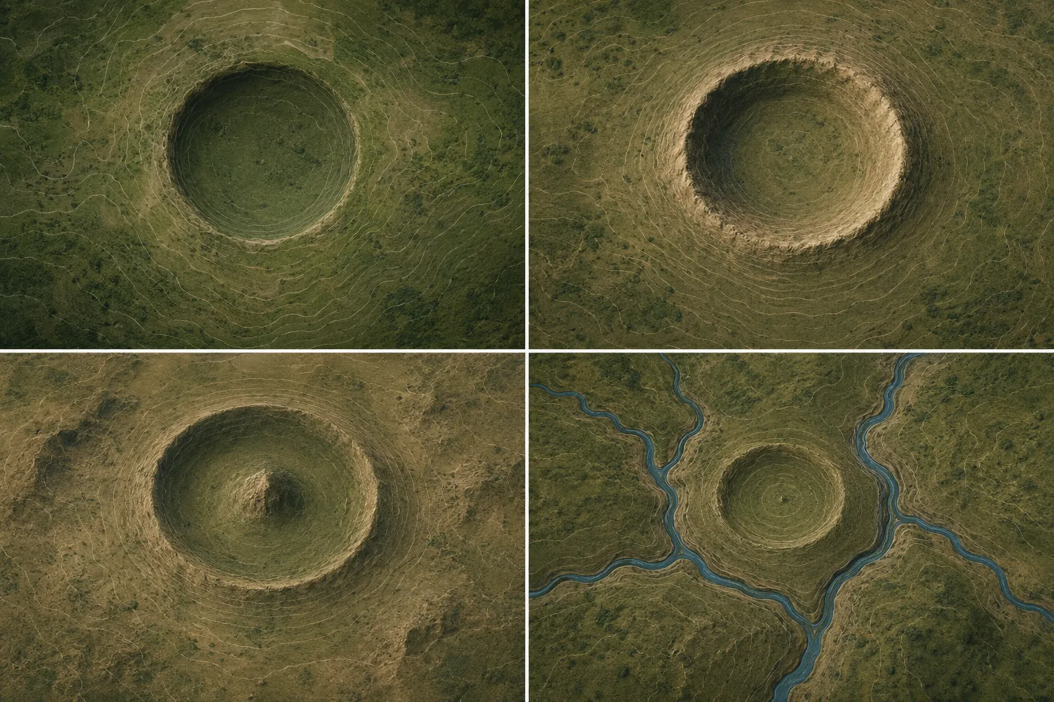
A candidate crater does not need to show every feature perfectly. Earth is too messy for that. But you should check the same four traits each time so your project does not become a collection of interesting circles.
1. A Near-Circular Depression
Start with shape, but do not stop there. An impact crater often appears as a circular or nearly circular depression because the impact excavated material from the target surface. On Earth, later erosion can stretch, soften, or partly erase that outline. Your notes should describe the shape honestly: “nearly circular,” “oval,” “broken ring,” or “partial arc.”
Measure the apparent rim-to-rim diameter in Google Earth using the ruler tool. Record the unit, the start and end points, and whether you measured across a lake, a ridge, or a visible contour. If the feature is not equally wide in different directions, measure two diameters and say so.
2. A Topographic Ring Or Raised Rim
A raised rim is more useful than a pretty outline. Look for a ring that remains visible when terrain is emphasized: a ridge around a basin, a circular break in slope, or a lake that follows the inside edge of a ring. The LPI’s educational materials describe rims and ejecta as key parts of impact-crater morphology, though preservation varies from crater to crater.[7]
Use the tilt view carefully. A little tilt can reveal relief; too much tilt can exaggerate ordinary hills into a dramatic wall. Take one screenshot from above and one with terrain relief visible. Label both.
3. A Central Uplift In Larger Structures
Larger impact structures can develop central uplifts, where deep rocks rebound upward after impact. This does not mean every crater has a neat mountain in the middle. Small simple craters may lack one, and old central uplifts may be eroded, submerged, or hidden under sediment. Still, if you see a circular basin with an isolated central high area, mark it as an observation worth checking.
Avoid forcing the evidence. A normal island in a lake is not automatically a central peak. Ask whether the “peak” is centered, whether it aligns with surrounding geology, and whether the rest of the structure supports an impact interpretation.
4. Drainage That Bends Around The Feature
Streams are excellent tattletales. A raised rim can redirect water around a circular feature. A basin can collect lakes or wetlands. On a map, look for rivers that curve around the outside of a ring, streams that enter gaps in the rim, or lakes arranged along a circular outline.
This is also where false positives start shouting. Glacial landscapes can leave round kettle lakes. Sinkholes can form circular depressions. Volcanic calderas can be huge, round, and rimmed. Do not award full credit to a candidate just because water made a beautiful circle.
The False Positives That Fool Good Students
Osinski’s warning is the right mood for this project: “I get lots of messages from the public thinking they have found a crater and 99/100 turn out not to be the case,” he told Live Science.[2] That is not a reason to quit. It is a reason to make your false-positive section the strongest part of the project board.
| False Positive | Why It Looks Crater-ish | What To Check |
|---|---|---|
| Volcanic caldera | Large circular basin with steep walls or a lake inside. | Look for nearby volcanic cones, lava flows, ash deposits, or a regional volcanic chain. |
| Glacial kettle lake | Round lake or pond left by melting buried ice. | Check whether the area is full of many small round lakes instead of one isolated structure. |
| Sinkhole | Circular depression caused by collapse, often in limestone or other soluble rock. | Look for karst terrain, clusters of depressions, and lack of a raised rim. |
| Quarry or mine | Circular or terraced pit with sharp edges. | Look for roads, benches, machinery scars, spoil piles, and recent imagery changes. |
| Atoll | Ring-shaped island or reef around a lagoon. | Check whether it is in a tropical ocean setting and related to reef growth, not bedrock impact. |
| Salt dome | Circular uplift or depression linked to rising salt underground. | Check regional geology and whether the feature sits in a sedimentary basin known for salt structures. |
A useful trick is to write the false-positive explanation before writing your conclusion. If you cannot explain why your feature is unlikely to be a quarry, sinkhole, caldera, kettle lake, atoll, or salt structure, you are not ready to call it an impact-crater candidate.
How To Document A Candidate Without Overclaiming
Documentation is where a science project becomes more than a map tour. Use one candidate, or a small set of candidates, and document each one the same way. If you find out that your best circle is already a known crater, that is still a successful project. You can compare your observations with the database record and explain which map features matched the confirmed structure.
- Record latitude and longitude from Google Earth, including the format you used.
- Take a top-down screenshot with the feature centered and north visible.
- Take a terrain-view screenshot showing relief, rim, basin, or drainage.
- Measure the apparent diameter with the ruler tool and note exactly what you measured.
- Describe the four visual checks: circularity, rim, central uplift, and drainage pattern.
- Check the candidate against crater databases and record whether it appears there.
- Write a false-positive paragraph that explains the most likely non-impact alternatives.
Coordinate care matters. Even published or public-facing references can use slightly different center points for a large structure, depending on how the center is estimated or rounded. For your own project, do not pretend that one click gives perfect location certainty. Say whether your coordinates mark the center of the basin, the center of a lake, the highest part of a central feature, or your best estimate of the overall structure.
Your conclusion should match your evidence. Good wording sounds like this: “This feature is a circular depression with a possible raised rim and disrupted drainage. I did not find it listed in the crater references I checked. Because satellite imagery cannot confirm shock features, I classify it as an unverified candidate and discuss several false-positive explanations.” That is not timid. That is how evidence behaves.
Cross-Reference Like A Scientist, Not A Treasure Hunter
Use at least three references when checking a candidate. Start with the Earth Impact Database for confirmed structures, but remember that the public site’s update status is old.[4] Then check the Impact Earth interactive map, which is associated with Western University’s impact-crater work.[5] Finally, compare the Impact! Meteor Crater Viewer as a quick map-based reference.[6]
If your feature appears in a database, your project can shift from “candidate search” to “map evidence comparison.” Ask which features were visible from satellite imagery and which confirmation evidence required field geology. If your feature does not appear in the databases, your project should become more cautious, not more dramatic.
This is the same habit that helps on evidence-heavy exams. In ACT Science Reasoning, students have to compare graphs, methods, and competing explanations. In MCAT CARS, they have to track what a source actually supports instead of what it merely suggests. A crater project is not an exam drill, but it trains the same discipline: separate observation, inference, and proof.
A Science-Project Claim That Holds Up
The strongest version of this project is not “I found a new meteorite crater on Google Earth.” The strongest version is “I used Google Earth to identify and evaluate circular landforms, compared them with confirmed impact structures, measured a candidate, checked crater databases, and ruled out likely false positives.”
That leaves room for real wonder. Uhackatik shows that careful looking from home can matter. It also shows why the boring part is not optional. The map raised a question; field evidence answered it. For your science project, the win is learning to ask the question so clearly that someone else can see exactly how you checked it.
References
- An Amateur Astronomer Using Google Maps Spotted a Strange Indentation. It Turned Out to Be a Meteorite Crater From 390 Million Years Ago — Smithsonian Magazine, July 2026
- Scientists confirm that 15-mile-wide pit found on Google Maps is ancient meteor crater — Live Science, July 2026
- How can I tell if I have found an impact crater? — USGS
- Earth Impact Database — PASSC/University of New Brunswick
- Impact Earth Database interactive map
- Impact! Meteor Crater Google Map Viewer
- Shaping the Planets: Impact Cratering — Lunar and Planetary Institute
Related exhibits & inventory
Verified outcomes
No verified outcomes on file for this exam yet
See Methodology for how outcome evidence is disclosed once logged.
Planners
No planner filed for this exam yet
A downloadable timeline template for this exam hasn't been published yet.
Tool verdicts
AI-tool cautions
No AI tools tested for this exam yet
No hands-on AI-accuracy logs have been filed for this exam.
Questions about this plan
Ask a question about a specific section, timeline, or citation in this plan — or flag something that needs correcting.
Comments
Join the discussion with an anonymous comment.